Into the Metaverse: A Look at How Riverside Research Technology Prepares and Protects Our GEOINT-Enabled Warfighters
The combination of geospatial intelligence (GEOINT) and the metaverse has produced dramatic changes and opportunities in the intelligence community. Riverside Research, a national security nonprofit, has found exciting ways to use publicly and privately available data to create simulated environments in the metaverse, enabling the company to provide new capabilities to their GEOINT customers in the Department of Defense community.

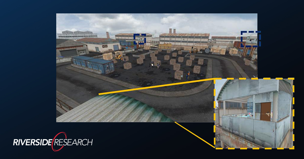
While this type of development has many applications, Riverside Research already provides metaverse environments to warfighters for the purposes of training and accurately preparing for on-the-ground missions. Riverside Research’s technology can do this by generating synthetic data to better train warfighter algorithms and metaverse-enabled simulation environments for “warfighter-in-the-loop” edge case testing.
What is Geospatial Intelligence?
Geospatial intelligence, or GEOINT, is a rich science relying on positioning and data. In a contemporary context, GEOINT involves learning about locations and on Earth with the use of reliable data from sources such as satellites and other surveillance craft. You likely use this technology every day: your car’s GPS relies on geospatial data to get you safely from one place to another.
In the field of GEOINT, scientists and researchers collect, collate, and analyze data to make predictions and identify themes or anomalies presented in the data. With this type of data and analysis, the intelligence community can make more informed decisions based on recent and real-time data.
What is the Metaverse?
The metaverse is a virtual environment permitting simulated experiences with humans and the environment. Imagine exploring an abandoned castle, a speculative spaceship design, the Mariana trench, or even a volcano’s caldera, all from the safety of your home or office. Soon, visitors will be able to virtually explore protected habitats like the Galapagos Islands or terrain typically considered too dangerous to explore due to lingering ordnance like unexploded land mines.
Many corporations see value in the metaverse as a social gathering place where people can engage in shopping and pay for experiences and even virtual real estate. For the intelligence community, the technological advantages are incomparable, and of serious interest to the federal governments. The metaverse is likely to affect and provide us opportunities to optimize all parts of the planning, collection, processing, exploitation/analysis, and dissemination portions of the classic “intelligence cycle.”
Advancements in the Metaverse in the Science and Technology Fields
The metaverse's main advantages in technical and scientific fields are already evident. Medical students can practice complicated procedures in virtual environments. Warfighters can train in a variety of conditions and can even do alpha tests of sophisticated novel equipment, airplanes spacecraft, and weapons technology.
Using GEOINT data and the metaverse, scientists can identify and analyze points of climate change all around the world. This technology is fast and accurate, saving time and money while significantly lowering the risk and cost of having personnel at a location for direct experience and testing.
When gathering location-based intelligence, an analyst’s job involves doing their best to gather multiple sources of information, synthesize that data, and present it to decisionmakers who conduct on-the-ground operations in zones of conflict. When possible, an analyst uses all available intelligence to inform the warfighter of conditions at the operation site, including historical and real-time data.
Into the Metaverse with GEOINT at Riverside Research
Bill Casebeer, Riverside Research Director, describes metaverse technology as a capability that removes many disadvantages. By feeding GEOINT data directly into a metaverse environment, those planning and conducting operations can get practice navigating terrain, determining and interacting with points of entry, and assessing when and where they might need more cover. They can use these GEOINT-informed environments to practice with their algorithmic tools. (“Is that a potential target? Can the adversary see me from their position?”)
Riverside Research meets this national security challenge by designing and developing metaverse technology in conjunction with GEOINT to better protect the warfighter and more efficiently engage in intelligence gathering, ultimately streamlining expenses and minimizing danger by allowing their researchers to make design decisions for technology well before deployment.
This technology increases the ability to protect the warfighter and other participants because it allows for interactive training, testing, and mission simulation, all from the safety of a base, laboratory, or other secure facility.
This technology is undoubtedly a boon to intelligence, with immersive environments becoming increasingly interactive, realistic, and full over time. Applying GEOINT and other forms of data to metaverse environments has created a new era of situational awareness for every plane in the sky, every ship in the sea, and every boot on the ground.
The Future of the Metaverse and GEOINT
What’s next in the marriage of geospatial intelligence and the metaverse? It’s entirely possible to build more immersive environments in the future. If you think the Star Trek “holodeck” is in the far future, know that it could be closer than you think. With more immersive capabilities, technology could provide the warfighter with the ability to feel an extreme temperature in their simulation or adjust to time of day or the amount of sand or dust in the air in a way that isn’t entirely possible with current capabilities.
Additionally, the metaverse represents another area to protect and defend, just as we currently do with any connected virtual space susceptible to interference or cyberattack. With interface models like the ubiquitous ChatGPT from OpenAI, metaverse technology and programming could become accessible to just about anyone – whether a civilian consumer touring the world, or a bad actor looking to damage a virtual or physical environment.
“The intersection of virtual reality and metaverse technologies with artificial intelligence and machine learning offers a new high ground for GEOINT analysts and the warfighters they work with to better optimize planning and training and ultimately produce tested and validated algorithms and digital assistants to improve team performance,” notes Bill.
To learn more about Riverside Research’s foray into the metaverse powered by GEOINT data and analysis, come to booth 923 at the United States Geospatial Intelligence Foundation (USGIF) 2023 Geoint Symposium or view our virtual booth for the symposium. The event takes place on May 22-24 in St. Louis.