We Are Better Together
Our Commercial Innovation Center (CIC) is a first-of-its-kind, online development and test platform that provides a secure, virtual, open ecosystem and test sandbox for developers and researchers. We do it by harnessing the combined powers of commercial remote sensing, unclassified open datasets, cloud technologies, in a secure development ecosystem fueled by new, emerging, and seasoned tools, services and data to create solutions that keep our nation safe. The Riverside Research CIC is the place where commercial subject matter experts come together securely to collaborate and create the best commercial solutions to real world scenarios before they're integrated and deployed in the field.
Together, we win
It’s not as much fun to play in the sandbox by yourself, right? We know from experience that it’s the collective work of many people with diverse experiences and backgrounds that create the most effective solutions. By design, the CIC encourages partnerships, increases data accessibility, integrates app development, and facilitates the creation of transition-ready prototypes. Because of our unique position as a nonprofit in the defense space, we can provide the neutral environment where collaborative innovation thrives. As demonstrated on this video, capitalizing on all commercial sensors available improves our progress towards persistent observation.
Access to rich datasets
Data is the one thing that is guaranteed to continuously grow and change. Technology entrepreneurs’ success revolves around access to these data and developing improved AI and machine learning tools creating integrated and advanced applications for businesses in support of (United States Government) USG needs.
Advanced tools and applications
Technology innovation in artificial intelligence, machine learning, and augmented and virtual reality present significant entrepreneurial opportunities, yet all require geospatial data for development. Early-stage entrepreneurs, academic researchers, and innovators will now have access to the large datasets that are traditionally only available to large, established industry players. Such datasets are often too costly for early-stage entrepreneurs and researchers to acquire, and even if the datasets are made available, they are often not packaged in a manner that allows innovators to work with the data—they are overwhelmingly unwieldy and non-standardized. The CIC data environment seeks to solve that problem, allowing researchers and entrepreneurs new opportunities for experimentation, testing, and training.
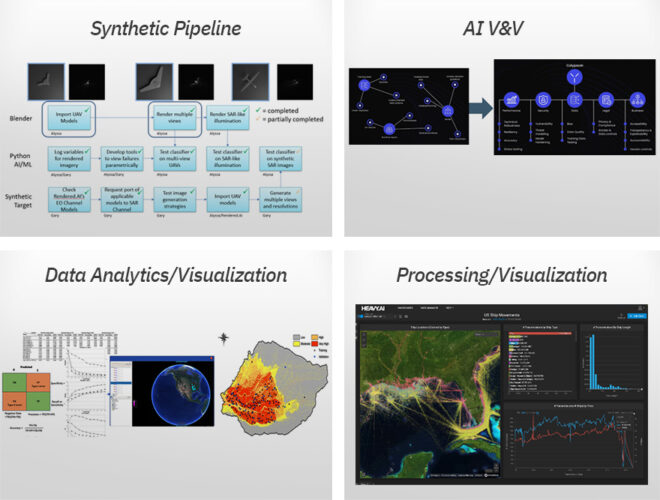
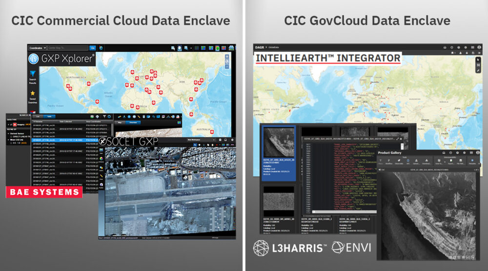
The CIC pairs this data with tools and services to streamline development timelines by ensuring flexible licenses are available for your R&D activities within the CIC ecosystem. As new tools and services become available, we negotiate with the vendors for early and shared access amongst our CIC participants to the latest and greatest capabilities from established vendors in the remote sensing market. This visual shows a few or our early integrators, and as new vendors are integrated, we’ll let the community know!
Your all-access pass
The CIC supports and enables industry, scientific, academic, and governmental R&D activities by facilitating access to commercial remote sensing data. Riverside Research integrates the hardware, software, processes, data, tools, internet accesses, demonstration capabilities, and other IT infrastructure required to execute CIC participant SIBR projects and meet R&D objectives. Our CIC offers:
- Exposure to diverse and emerging data and data types for more data scientists
- Increased interaction between content providers and new application developers; enables cloud-hybrid, multi-INT applications
- Lowered entry barriers by eliminating the need for a user-developed system
- Integrated orchestration-to-analysis workflow
- Timely teaming, technology, and tipping
- Accelerated access and use of commercial remote sensing solutions and innovation
Right where you want it
Are you looking for a cloud-hosting environment where you can easily access commercial data for development and test—all from one place to safely develop, load, and test capabilities?
Our trusted, unclassified, virtual development platform provides access to R&D-licensed commercial remote sensing phenomenologies (e.g., EO, radar, IR, RF), connects emerging and established vendors with shared application tools and services, and facilitates GEOINT, MASINT, and Multi-INT research and development. The CIC includes:
- An ecosystem of commercial data providers (CDPs)
- A network of application developers
- Common R&D data and COTS/GOTS tools (e.g., loading, discovery)
- Common testing data (curated, tagged)
- Robust DevOps environment
- Hybrid cloud-ready infrastructure
- Protected intellectual property and data rights
- Maturing secure data fabric
CIC mission, vision & values
Mission: Provide data scientists and algorithm developers with a virtual development and test platform and access to new and diverse commercial remote sensing data to develop algorithms, tools, and services.
Vision: Work in the Nation’s interest to offer proven expertise and experience in commercial remote sensing to solve problems through innovation, agility, and creative thinking.
Values: Encourage partnerships and connect emerging and established users across USG and industry with shared application tools, services, and diverse commercial constellation data.

Participant Agreements: We offer access to a secure, virtual, cloud-based ecosystem to perform R&D using existing and emerging commercial sources to develop and test algorithms, tools, and services accelerating USG objectives.
Commercial Experts: We offer our commercial experience, data scientists, and phenomenology experts to support efforts using the CIC to perform commercial utility assessments, new sensor development, synthetic data V&V, data value/usability studies, and more.
Products and Services: We offer access to CIC-based products and services such as synthetic data generation, data tagging, AI/ML V&V, data compression, data geo-registration, and more.
Work With the Commercial Innovation Center
Press Inquiries About the CIC
Commercial Innovation in the News
- Commercial Imagery
- Satellite Launches
- EO-MSI
- SAR
- HSI
- RF
- SSA
Commercial Imagery
NEW: National Weather Service confirms additional tornadoes from weekend storms
The tornado may have continued slightly farther northeast, but confirmation will require further satellite imagery analysis. Peoria, MS: EF-1 ...
Flipping the Script: Redesigning the US Air Force for Decisive Advantage | Hudson Institute
True color satellite image shows Earth centered on the North Pole with cloud coverage during summer solstice in 2002. (Getty Images). National ...
There's a lot of big talk about sovereign launch—who is doing something about it?
Commercial satellite companies will still choose the ... Rocket Lab, which operates the Electron small satellite launcher seen in this image ...
Tracking the US military buildup near Iran | CNN
Flight data and satellite imagery reveal how the US is positioning forces amid rising tensions. CNN's Jeremy Diamond reports. 2:03 • Source: CNN.
U.S. offers more details on claim China conducted secret nuclear test - The Washington Post
... satellite image shows a recently developed area at China's Lop Nur nuclear testing site. (Planet Labs). China has long declined to participate in ...
BlackSky Secures Eight-Figure International Contract for Sovereign Gen-3 Satellite Solution
The agreement includes the sale of a single high-resolution Gen-3 satellite, multi-year on-orbit operations, and subscription-based “Assured” imagery ...
Multi-Sensor Fusion of Sentinel-2 Imagery and ICESat-2 Satellite Laser Bathymetry for ...
Multispectral imagery has traditionally been used to classify ... Satellite Laser Bathymetry for Benthic Habitat Classification in Key ...
Wrivinder: Towards Spatial Intelligence for Geo-locating Ground Images onto Satellite Imagery - arXiv
Aligning ground-level imagery with geo-registered satellite maps is crucial for mapping, navigation, and situational awareness, yet remains ...
SatVu Closes Funding Round of $40M, With NATO Innovation Fund Backing - Via Satellite
Imagery and Sensing BlackSky International Customer Orders Gen-3 Satellite for Sovereign Access ... satellite constellation. The company ...
U.S. releases new details on alleged secret Chinese nuclear test - OPB
The U.S. government has released fresh intelligence on what it claims was an illicit Chinese nuclear test conducted in 2020. ... Satellite imagery has ...
Geneva hosts diplomatic talks on Iran and Ukraine | CNN
Flight data and satellite imagery reveal how the US is positioning forces amid rising tensions. CNN's Jeremy Diamond reports. 02:02 • Source: CNN.
Teaching AI to read a map - Google Research
More intuitive navigation tools: An AI model that can look at a satellite image or a complex subway map and give you truly intuitive, visually ...
Maps & America: The Arthur Holzheimer Lecture Series - UW-Milwaukee
MapBiomas is a Brazilian-founded initiative that uses cloud computing, machine learning, and decades of satellite imagery to produce large‑scale, time ...
A New Look at North Korea's Economic Redistribution During the COVID-19 Pandemic
Evidence from nighttime satellite imagery indicates that the distribution of economic activity in North Korea (Democratic People's Republic of ...
Some forest restoration linked to short-term rise in zoonotic diseases - Mongabay
Malaria outbreak among Indigenous Pirahã linked to forest loss, satellite data find. Aimee Gabay 17 Feb 2026 · Satellite image of the eastern part of ...
BlackSky International Customer Orders Gen-3 Satellite for Sovereign Access
BlackSky Technology announced a deal with an unnamed international customer for a dedicated Gen-3 satellite, along with BlackSky's imagery and ...
Tracking the US military buildup near Iran - CNN
... closer to the region. Flight data and satellite imagery reveal how the US is positioning forces amid rising tensions. CNN's Jeremy Diamond reports.
NOAA's Next JPSS Weather Satellite, JPSS-4, Completes Solar Array Deployment Test
The JPSS-4 satellite's five instruments gather measurements of conditions in the atmosphere, in the ocean, and on land. Credit: NOAA. Download Image ...
Imagery Update: Taleghan 2 Facility is Now Being Buried | ISIS Reports - Isis-online.org
Satellite imagery from February 5, 2026, shows soil being added on top of the concrete sarcophagus; as of February 13, a large part of the ...
Amazon deforestation on pace to be the lowest on record, says Brazil - Mongabay
These figures come from INPE's DETER system, which uses near-real-time satellite imagery primarily to guide enforcement. While less precise than ...
Satellite Launches
BlackSky Secures Eight-Figure International Contract for Sovereign Gen-3 Satellite Solution
... imagery and analytics services. Transition ... satellite enter commercial operations in December 2025 following a successful Rocket Lab launch.
Trump 'Panics' As China Builds Submarines Faster Than Ever; Here's What Is Worrying Washington
... Satellite imagery points to major upgrades at key Chinese shipyards ... Iranian Special Forces Launch SURPRISE ASSAULT On US Ally; Trump, Netanyahu ...
Advanced Motorcycle-Focused GPS Equipment - Trend Hunter
Garmin has announced the launch of its newest and most advanced ... Offline High-res Mapping - Local storage of satellite imagery and high ...
Space Force Surveys Industry For Refueling Tech
Some of those will involve refueling satellites, like the Tetra-5 mission slated to launch later this year. ... satellite imaging technology and how it ...
A New Look at North Korea's Economic Redistribution During the COVID-19 Pandemic
Evidence from nighttime satellite imagery indicates that the ... launch sites (26.9% decrease) and districts with chemical facilities (15.7 ...
BlackSky International Customer Orders Gen-3 Satellite for Sovereign Access
... satellite, along with BlackSky's imagery and ... satellite in November delivering images from the satellite less than 24 hours after launch.
NanoAvionics to Offer Access to Kepler Communications Optical Relay Network
Connectivity Arianespace Launches 32 Amazon Leo Satellites in First Ariane 64 Mission · Imagery ... satellite link solutions. These capabilities ...
OTD in Space – February 17: NASA Launches 5 THEMIS Aurora-Hunting Spacecraft - Dailymotion
All five THEMIS satellites launched on the same Delta II rocket before ... Amazing Hubble Space Telescope Imagery Of A Globular Cluster In 4k.
NOAA's Next JPSS Weather Satellite, JPSS-4, Completes Solar Array Deployment Test
... satellite launch in NOAA's Joint Polar Satellite System (JPSS). As one ... Real-Time Imagery. Satellite Snapshots · Earth from Orbit · Imagery ...
China outpaces US in nuclear submarine launches over past five years
The report, titled “Boomtime at Bohai,” draws on satellite imagery of Chinese shipyards to estimate output. Beijing does not publicly disclose ...
A 'ring of fire' just appeared in the sky over Antarctica. Here's what happened during today's ...
... Images). Copy link; Facebook · X · Whatsapp · Reddit · Pinterest · Flipboard ... satellites into orbit on launches from California and Florida · An ...
Kipu Quantum Launches Rimay Quantum Feature Extraction Service
KPMG used Rimay to classify tree species from limited satellite imagery, delivering clearer quantum-enhanced environmental intelligence. Moeve used ...
Blastoff! SpaceX launches 29 Starlink satellites from Florida, nails landing - YouTube
A SpaceX Falcon 9 launched 29 Starlink satellites from Space Launch Complex 40 (SLC-40) at Cape Canaveral Space Force Station in Florida on Feb.
Pixxel, Exotrail Partner to Power Earth Observation Satellites | Analytics India Magazine
Pixxel will deploy Exotrail's spaceware propulsion systems across future satellite launches ... Pixxel builds and operates hyperspectral imaging ...
Which countries are actually serious about developing their own rockets? - Ars Technica
... launch their satellites on European rockets, but that's not always possible. ESA and the EU launched several key satellite missions on SpaceX ...
Airbus taps Synspective SAR radar network for expanded Earth imaging - SpaceWar.com
Synspective is in the process of expanding its SAR constellation with regular launches, targeting a fleet of around 30 satellites by the end of the ...
SatVu to expand thermal imaging constellation with NATO-backed funds - SpaceNews
SpaceX was previously lined up to launch SatVu's HotSat-2 and HotSat-3 satellites, both built by U.K.-based Surrey Satellite Technology Ltd. (SSTL), ...
Protecting the world's most critical energy region with AI satellite analysis
Geospatial analytics is the analysis of satellite imagery, and is ... The Intelligent Pipeline Integrity Program (iPIPE), as it was called, was launched ...
Spexi Orthomosaic Drone Imagery Now Available on SkyWatch Platform - Dronelife
With the launch, SkyWatch customers can access Spexi's stitched, orthorectified imagery over 38 cities across North America. Each dataset supports ...
China's 09V sub signals shift in Pacific's undersea power - Asia Times
... launch bay at the Bohai Shipbuilding Heavy Industry yard in Huludao, satellite and radar imagery show, marking a significant milestone in the ...
EO-MSI
BlackSky Secures Eight-Figure International Contract for Sovereign Gen-3 Satellite Solution
Integration with Existing Constellation. Until the dedicated satellite enters service, the customer will utilize BlackSky's “Assured” services ...
Assured Intelligence Delivery: Strengthening ISR Predictability for Australia's Indo-Pacific Missions
A satellite must then pass over the area under suitable conditions, capture the imagery, process the data and deliver it to the end user. Each step in ...
BlackSky secures eight-figure contract for Gen-3 satellite and services - TipRanks.com
BlackSky (BKSY) Technology secured a new eight-figure international contract for accelerated delivery of a Gen-3 sovereign space-based ...
Kratos awarded multi-million contract from Airbus to deliver ground system for OmanSat-1 ...
SCT selected Airbus Defence and Space to deliver OmanSat-1, a fully reconfigurable high-throughput OneSat satellite and its associated ground system, ...
SatVu Closes Funding Round of $40M, With NATO Innovation Fund Backing - Via Satellite
Imagery and Sensing BlackSky International Customer Orders Gen-3 Satellite for Sovereign Access ... satellite constellation. The company ...
ST Engineering iDirect Partners with G&S SatCom to… - AAP News
HERNDON, Va., Feb. 17, 2026 /PRNewswire/ -- ST Engineering iDirect, a global leader in satellite communications, today announced a strategic…
Bradley County Announces Site Locations For Property Tax Collection - Chattanoogan.com
He said, “The satellite locations have been very popular with taxpayers. They have eliminated the need for citizens to come to the office and have ...
BlackSky International Customer Orders Gen-3 Satellite for Sovereign Access
BlackSky Technology announced a deal with an unnamed international customer for a dedicated Gen-3 satellite.
What's Going On With BlackSky Technology Stock Tuesday? - Finviz
The agreement covers the sale of a Gen-3, very high-resolution 35-centimeter satellite, multi-year on-orbit operations, and subscription-based Assured ...
What's Going On With BlackSky Technology Stock Tuesday? - Benzinga
BlackSky Technology Inc. (BKSY) stock rose after signing an eight-figure contract for an advanced satellite solution.
Iran signals nuclear progress in Geneva as Trump calls for full dismantlement - Fox News
damage at the Fordow enrichment facility. This satellite image provided by Maxar Technologies shows damage at the Fordo enrichment facility in Iran ...
Lean into the ride on the open road or closed track with zūmo XT3 from Garmin | Nasdaq
Satellite imagery © 2026 Maxar Technologies (date of satellite imagery may vary). The Bluetooth word mark and logos are registered trademarks ...
Stocks Flashing Renewed Technical Strength: BlackSky Technology
The company earns the No. 6 rank among its peers in the Telecom Services-Cable/Satellite industry group. Planet Labs PBC (PL), Comcast Cl A (CMCSA) ...
AI transforming farming, says Maha official; cites smart cow necklaces, satellite sugar tests
On soil testing, she said portable devices under the Vasudha and Neo Park programmes use hyperspectral imaging to deliver a complete soil chemical ...
Ukrainian drone maker Skyeton integrates satellite communications into Raybird UAS to ...
BlackSky signs eight-figure international ...
Digital forestry team combines AI with satellite data to monitor urban trees
And because the data they use from the PlanetScope constellation of 130 satellites includes 15 years of historical records, the system can ...
Blacksky Technology Inc. Signs New Eight-Figure International Contract for Accelerated ...
Once operational, the Gen-3 satellite will work in parallel to BlackSky's constellation to deliver mission-relevant insights at speeds. Gen-3's ...
BlackSky (BKSY) Secures Major Contract for Gen-3 Space Intelligence Solution - GuruFocus
Key Takeaways: BlackSky Technology (BKSY) secures a major international contract for its Gen-3 satellite technology.
BlackSky signs eight-figure international deal for accelerated delivery of Gen-3 sovereign ...
The agreement includes the sale of one Gen-3 very-high resolution 35-centimeter satellite along with recurring, multi-year on-orbit operations and ...
BlackSky Signs New Eight-Figure International Contract for Accelerated Delivery of Gen-3 ...
BlackSky possesses proprietary in-house satellite design and agile manufacturing, constellation operations and end-to-end advanced software ...
SAR
A Rare Look Inside Canon's Incredible Winter Olympics Gear Room in Milan | PetaPixel
Cable brought a lot of his own gear with him to Italy, of course, including Canon EOS ... Satellite view of the snow-covered Alps mountains with deep ...
Santa Barbara-Based Space Technology Company Expands to Virginia with $6.75 Million Investment
The $6.75 million investment will support Umbra's continued growth in remote sensing and satellite system development. The new facility is ...
Ghost Release Steamy New Video For 'Umbra' - RTTNews
Swedish rock band Ghost recently shared a steamy new video for "Umbra," a track from the band's album Skeletá ... Constellation Brands Stock Falls 5% ...
AAC Clyde Space Initiates Earth Observation Expansion | Aviation Week Network
Related Content. ymir satellite · AAC Clyde Space Expands Maritime Data Satellite Fleet · Iceye satellite images Stockholm · Sweden Joins Iceye SAR ...
ASII launches national geospatial digital twin for Australian agriculture - Space Daily
... PAZ satellite flying in constellation with the German TerraSAR-X and TanDEM-X missions. EARTH OBSERVATION · International crew takes off for space ...
Airbus taps Synspective SAR radar network for expanded Earth imaging - Space War
Paris, France (SPX) Feb 17, 2026 - Airbus Defence and Space has signed a new radar satellite ... TerraSAR-X, TanDEM-X and PAZ. The combined fleet is ...
Santa Barbara Satellite Company Umbra Expanding to Virginia | Local News | Noozhawk
A satellite manufacturing company launched in Santa Barbara will expand again, adding a large facility in Virginia. Umbra last week announced ...
PSLV-C62's fourth stage ignited before descent: Orbital Paradigm
The rocket carried India's strategic satellite EOS-N1 as primary passenger and 15 other small satellites belonging to Indian and foreign entities.
HSI
Exotrail Secures Major Propulsion Contracts with Indian Space Firms During Presidential Visit
Pixxel: A first-time contract to equip the planetary intelligence company's high-resolution imaging constellation with Hall-Effect propulsion.
Exotrail to provide electric propulsion systems to Pixxel - UNITED NEWS OF INDIA
Uniindia: Chennai, Feb 17 (UNI) Indian satellite company Pixxel has signed an agreement with French electric propulsion provider Exotrail to power ...
Exotrail to provide electric propulsion systems to Pixxel - UNITED NEWS OF INDIA
Chennai, Feb 17 (UNI) Indian satellite company Pixxel has signed an agreement with French electric propulsion provider Exotrail to power its upcoming ...
AI transforming farming, says Maha official; cites smart cow necklaces, satellite sugar tests
AI transforming farming, says Maha official; cites smart cow necklaces, satellite sugar tests ... Pixxel, Dhruva Space select Exotrail thrusters to ...
India and France Unite: Space-Tech Pioneers Launch Satellite Ventures - Devdiscourse
Pixxel Space and Dhruva Space collaborate with Exotrail, a French propulsion provider, to advance satellite tech.
Pixxel, Dhruva Space select Exotrail thrusters to steer satellites in orbit - Press Trust of India
According to the agreement, Pixxel will integrate Exotrail's "spaceware" electric propulsion systems across its upcoming satellite deployments, with ...
Northstar Extends Maturing Convertible Debentures - Stock Titan
... Satellite · All Stock Rankings Largest Companies by Market ... For further information about Northstar, please visit www.northstarcleantech.com.
Pixxel, Exotrail Partner to Power Earth Observation Satellites | Analytics India Magazine
Pixxel will deploy Exotrail's spaceware propulsion systems across future satellite launches through 2027.
Pixxel and Exotrail Announce Electric Propulsion Contract to Power Next-Generation Earth ...
The systems will support Pixxel's expanding Earth Observation constellation and broader space infrastructure roadmap. Pixxel's constellation is ...
Pixxel partners with Exotrail to boost satellite capabilities - NewsBytes
Space-tech startup Pixxel Space has partnered with French firm Exotrail to utilize its electric propulsion systems for steering Pixxel's advanced ...
Pixxel selects Exotrail thrusters to steer its satellites in orbit - The Economic Times
"Under this agreement, Pixxel will integrate Exotrail's spaceware electric propulsion systems across its upcoming satellite deployments, with ...
Sovereign AI Models Launched at AI Impact Summit - Rediff Money
Pixxel & Exotrail Partner for Satellite Thrusters. Pixxel selects Exotrail thrusters to steer its satellites in orbit. Partnership boosts ...
India's AI Revolution: Sovereign Models Set to Transform Digital Landscape - Devdiscourse
Pixxel Space Partners with French Firm to Propel Satellite Innovation ... satellite constellation and its overarching space infrastructure ambitions.
AI for Agriculture: Bridging the Information Gap - Rediff Money
MeitY Secretary S Krishnan calls for using AI to bridge the information gap in... Pixxel & Exotrail... Pixxel & Exotrail Partner for Satellite ...
Pixxel selects Exotrail thrusters to steer its satellites in orbit - Press Trust of India
New Delhi, Feb 17 (PTI) Space-tech startup Pixxel Space on Tuesday announced partnership with French electric propulsion provider Exotrail to ...
Pixxel Space Partners with French Firm to Propel Satellite Innovation - Devdiscourse
Pixxel Space has partnered with Exotrail, a French propulsion provider, to enhance its satellite capabilities. This collaboration will integrate ...
Exotrail Secures Landmark Propulsion Deals with Indian Space Firms - Devdiscourse
The contracts involve prominent Indian companies like Dhruva Space, a satellite manufacturer; Pixxel, a space infrastructure developer; and XDLINX ...
Exotrail Secures Landmark Propulsion Deals with Indian Space Firms - Devdiscourse
... Pixxel, and XDLINX Labs, significant ... The contracts involve prominent Indian companies like Dhruva Space, a satellite manufacturer; Pixxel ...
Topcon secures early access to Xona's Pulsar satellite navigation service - GPS World
... satellite navigation constellation. This agreement ... Modern Northstar: Starlink LEO PNT across land, air, stratosphere and Arctic Seas.
RF
BrightSpire Capital, Inc. Announces Fourth Quarter & Full Year 2025 Financial Results
... Satellite · All Stock Rankings Largest Companies by Market Cap Best ... BrightSpire Capital, Inc. Announces Fourth Quarter & Full Year 2025 ...
BrightSpire Capital closes $955M CLO, to redeem 2021-FL1 | BRSP Stock News
... Satellite · All Stock Rankings Largest Companies by Market Cap Best ... BrightSpire Capital Announces Closing of $955 Million BRSP 2026-FL3 ...