We Are Better Together
Our Commercial Innovation Center (CIC) is a first-of-its-kind, online development and test platform that provides a secure, virtual, open ecosystem and test sandbox for developers and researchers. We do it by harnessing the combined powers of commercial remote sensing, unclassified open datasets, cloud technologies, in a secure development ecosystem fueled by new, emerging, and seasoned tools, services and data to create solutions that keep our nation safe. The Riverside Research CIC is the place where commercial subject matter experts come together securely to collaborate and create the best commercial solutions to real world scenarios before they're integrated and deployed in the field.
Together, we win
It’s not as much fun to play in the sandbox by yourself, right? We know from experience that it’s the collective work of many people with diverse experiences and backgrounds that create the most effective solutions. By design, the CIC encourages partnerships, increases data accessibility, integrates app development, and facilitates the creation of transition-ready prototypes. Because of our unique position as a nonprofit in the defense space, we can provide the neutral environment where collaborative innovation thrives. As demonstrated on this video, capitalizing on all commercial sensors available improves our progress towards persistent observation.
Access to rich datasets
Data is the one thing that is guaranteed to continuously grow and change. Technology entrepreneurs’ success revolves around access to these data and developing improved AI and machine learning tools creating integrated and advanced applications for businesses in support of (United States Government) USG needs.
Advanced tools and applications
Technology innovation in artificial intelligence, machine learning, and augmented and virtual reality present significant entrepreneurial opportunities, yet all require geospatial data for development. Early-stage entrepreneurs, academic researchers, and innovators will now have access to the large datasets that are traditionally only available to large, established industry players. Such datasets are often too costly for early-stage entrepreneurs and researchers to acquire, and even if the datasets are made available, they are often not packaged in a manner that allows innovators to work with the data—they are overwhelmingly unwieldy and non-standardized. The CIC data environment seeks to solve that problem, allowing researchers and entrepreneurs new opportunities for experimentation, testing, and training.
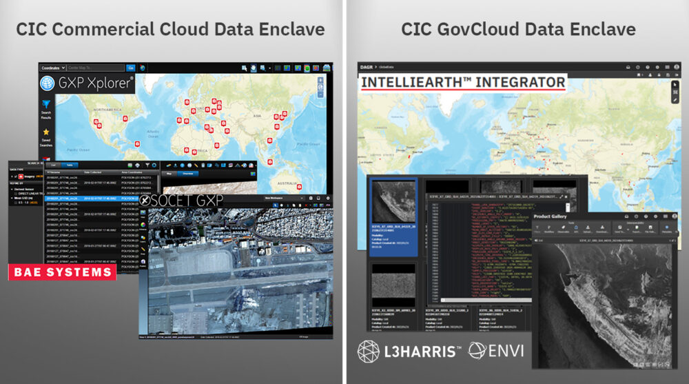
The CIC pairs this data with tools and services to streamline development timelines by ensuring flexible licenses are available for your R&D activities within the CIC ecosystem. As new tools and services become available, we negotiate with the vendors for early and shared access amongst our CIC participants to the latest and greatest capabilities from established vendors in the remote sensing market. This visual shows a few or our early integrators, and as new vendors are integrated, we’ll let the community know!
Your all-access pass
The CIC supports and enables industry, scientific, academic, and governmental R&D activities by facilitating access to commercial remote sensing data. Riverside Research integrates the hardware, software, processes, data, tools, internet accesses, demonstration capabilities, and other IT infrastructure required to execute CIC participant SIBR projects and meet R&D objectives. Our CIC offers:
- Exposure to diverse and emerging data and data types for more data scientists
- Increased interaction between content providers and new application developers; enables cloud-hybrid, multi-INT applications
- Lowered entry barriers by eliminating the need for a user-developed system
- Integrated orchestration-to-analysis workflow
- Timely teaming, technology, and tipping
- Accelerated access and use of commercial remote sensing solutions and innovation
Right where you want it
Are you looking for a cloud-hosting environment where you can easily access commercial data for development and test—all from one place to safely develop, load, and test capabilities?
Our trusted, unclassified, virtual development platform provides access to R&D-licensed commercial remote sensing phenomenologies (e.g., EO, radar, IR, RF), connects emerging and established vendors with shared application tools and services, and facilitates GEOINT, MASINT, and Multi-INT research and development. The CIC includes:
- An ecosystem of commercial data providers (CDPs)
- A network of application developers
- Common R&D data and COTS/GOTS tools (e.g., loading, discovery)
- Common testing data (curated, tagged)
- Robust DevOps environment
- Hybrid cloud-ready infrastructure
- Protected intellectual property and data rights
- Maturing secure data fabric
CIC mission, vision & values
Mission: Provide data scientists and algorithm developers with a virtual development and test platform and access to new and diverse commercial remote sensing data to develop algorithms, tools, and services.
Vision: Work in the Nation’s interest to offer proven expertise and experience in commercial remote sensing to solve problems through innovation, agility, and creative thinking.
Values: Encourage partnerships and connect emerging and established users across USG and industry with shared application tools, services, and diverse commercial constellation data.

Participant Agreements: We offer access to a secure, virtual, cloud-based ecosystem to perform R&D using existing and emerging commercial sources to develop and test algorithms, tools, and services accelerating USG objectives.
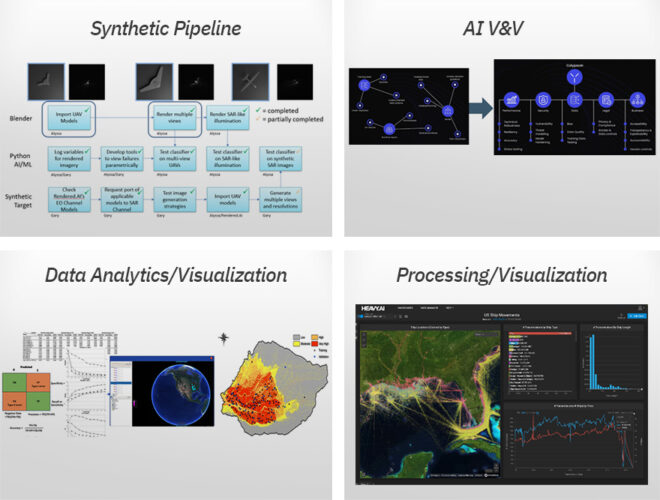
Commercial Experts: We offer our commercial experience, data scientists, and phenomenology experts to support efforts using the CIC to perform commercial utility assessments, new sensor development, synthetic data V&V, data value/usability studies, and more.
Products and Services: We offer access to CIC-based products and services such as synthetic data generation, data tagging, AI/ML V&V, data compression, data geo-registration, and more.
Work With the Commercial Innovation Center
Press Inquiries About the CIC
Commercial Innovation in the News
- Commercial Imagery
- Satellite Launches
- EO-MSI
- SAR
- HSI
- RF
- SSA
Commercial Imagery
Current nighttime RBG satellite imagery. | By US National Weather Service Pittsburgh PAFacebook
Current nighttime RBG satellite imagery. Some areas of low clouds and fog (cyan) have developed across the area, so allow a little extra time for ...
Thales and Pasqal Report Quantum Satellite Breakthrough
Pasqal and Thales Alenia Space have been using the power of quantum computing to make satellite technology more efficient and believe they have ...
Defining Built Environment From Satellite Images to Predict Cardiometabolic Disease
Urban planning and public health initiatives could benefit from integrating Google satellite image–derived environmental data to better understand ...
Satellite Image | Page 2 - Lawn Care Forum
Satellite Image. Jump to Latest Follow. JavaScript is disabled. For a better experience, please enable JavaScript in your browser before proceeding ...
(PDF) Using satellite imagery analysis in academic research - ResearchGate
7. Slide 18. Both images are taken from: Shelestov, A. et al (2023). 'War damage detection based on satellite data', ; 9. Geospatial intelligence –.
Satellite Imagery Shows Damage at Belbek Air Base - The Mercury
... Escape key or activating the close button. Satellite Imagery Shows Damage at Belbek Air Base. 6 hours ago. Storyful. Read More. Up Next. themercury.
Fires in Mexico, Central America send smoke towards Southeast | Fox Weather
... satellite imagery. Download the app. On Friday, Mexico's national forest commission reported 168 active wildfires have burned over a quarter of a ...
Revolutionizing Earth Science Satellite Imagery and Data Analytics in Action - YouTube
Revolutionizing Earth Science Satellite Imagery and Data Analytics in Action. 56 views · 7 hours ago ...more ...
NOAA extends partnership with CSU - Denver - 9News
And post storm research done at CIRA helps further the modeling and understanding of hurricane processes. Credit: CIRA-CSU-NOAA. Satellite image with ...
It's time to figure out global space traffic management - SpaceNews
The recent acquisition of geospatial intelligence firm Orbital Insight, which has a satellite imagery search engine platform, by Privateer, the ...
Hardwire Media | Earth's seasonal changes. a sequence of cloud-free satellite imagery ... - Instagram
95 likes, 2 comments - hardwire_media on May 17, 2024: "Earth's seasonal changes. a sequence of cloud-free satellite imagery mosaics of Earth over ...
Getting to Know the Geoprocessing Synthetic Aperture Radar Toolset - Esri
My education is in geophysics and my thesis work centered around understanding induced earthquake occurrences using seismic data and satellite imagery ...
Kenneth Roth on X: ""China has been aiding Russia with satellite intelligence and fighter jet parts ...
"China has been aiding Russia with satellite intelligence and fighter jet parts as well as supplying components with both civilian and military ...
China building world's first 'dedicated' drone carrier, satellite images suggest - Bangkok Post
Naval News reported on Wednesday that satellite imagery from the Jiangsu Dayang shipyard on the Yangtze, far upriver from the major yards of ...
Solved Cloud patterns in visible and infrared satellite | Chegg.com
Question: Cloud patterns in visible and infrared satellite images can be very helpful in identifying vorticity maxima in regions where elouds are ...
China launches new mystery Shiyan satellite (video) - Space.com
Chinese authorities provided no images of the satellite. The only description of the spacecraft states that Shiyan-23 will be used for space ...
Nearly 6 million trees disappeared from farmlands in three years, says satellite mapping study
For their analysis, the researchers combined satellite-imagery from two repositories – RapidEye and PlanetScope – to estimate changes in tree number ...
First aid shipment driven across new Gaza pier - The Hill
This satellite image from Planet Labs PBC shows a pier installed by the U.S. military in the Gaza Strip on Thursday, May 16, 2024. The United States ...
Satellite Imagery Shows Severe Storms Slamming Houston | NT News
... or activating the close button. Satellite Imagery Shows Severe Storms Slamming Houston. 9 minutes ago. Storyful. Read More. Up Next. ntnews.
How Tiny Djibouti Said 'No' to the U.S. Over Houthi Red Sea Attacks - gCaptain
A satellite image shows the cargo ship Rubymar before it sank, on the Red Sea. A satellite image shows the Belize-flagged and UK-owned cargo ship ...
Satellite Launches
SpaceX launches Falcon 9 rocket, Starlink satellites - ClickOrlando.com
SpaceX on Friday launched another batch of Starlink satellites to low-Earth orbit from Florida's Atlantic coast.
Exclusive: Andrea Williams joins Robinhood as head of corporate communications - Axios
... launches." Context: Williams most recently led ... Robinhood launches site for new media arm ... A satellite image of a storm over southeast Texas, ...
SpaceX launches Starlink 6-59 mission from Cape Canaveral Space Force Station in Florida
SpaceX launches Starlink 6-59 mission from Cape Canaveral Space Force Station in Florida ... satellites. Craig Bailey/FLORIDA TODAY via USA TODAY ...
SpaceX satellites threaten to hide asteroids that pose danger to humanity - EL PAÍS English
... satellite passes right in front of it in one or more of the images. ... First the satellites travel to space ... European Space Agency set to launch ...
SpaceX launch: Falcon 9 rocket carries Starlink satellites into orbit on Friday night
SpaceX launched 23 Starlink satellites into low-Earth orbit on Friday night ... SpaceX launched 23 Starlink satellites ... See Northern lights photos as ...
Putin says Russia wants a buffer zone in Ukraine's Kharkiv but has no plans to capture the city
Moscow launched attacks in the Kharkiv region ... satellite imagery of the airbase provided by Maxar Technologies. ... follow us. Explore. COVID · Archive ...
Karman Project Announces 2024 Fellowship Global Space Leaders
... Marble Imaging and Reflex Aerospace to Deploy EO Satellite Network. May 14, 2024 ...
New launch date as Boeing takes more time to assess Starliner helium leak
In this file photo, the Starliner space craft sits on top of the Atlas V rocket. A series of issues have plagued the maiden launch of the crewed ...
North Korea fires missile after Kim Jong-un's sister slams 'false rumour' of sending weapons ...
A TV screen shows a file image of North Korea's missile launch ... Friday's missile launches ... Satellite imagery suggests North Korea is supplying ...
SpaceX plans to launch 23 Starlink satellites from Florida - Yahoo
... Space Force Station. It would be the 21st mission for this Falcon 9 rocket. File Photo by Joe Marino/UPI More. May 17 (UPI) -- SpaceX plans to send ...
Satellite Synergies: EVP Shares Details on Dish Video/Hughes Internet Bundle
As Schanman explained, Hughes internet service is now delivered via Echostar's Jupiter 3 satellite, which is the largest satellite ever launched and ...
Israel-Gaza live updates: Bodies of 3 hostages recovered from Gaza - ABC News
75 launches detected from Lebanon into Israel Friday, IDF says ... satellite imagery by two university researchers. ... PHOTO: Ricarda Louk shows a photo ...
SatVu Orders 2 Thermal Imaging Satellites from SSTL
The satellites are both scheduled to launch in 2025. SatVu also announced on May 16 that the company closed a funding round. The company did not ...
There Is Too Much Trash in Space | Scientific American
There are almost 10,000 satellites in orbit right now, up from 6,500 only three years ago. The nearly 6,000 Starlink satellites launched by Elon ...
China launches new mystery Shiyan satellite (video) - Space.com
... launch was declared to be successful. Chinese authorities provided no images of the satellite. The only description of the spacecraft states that ...
Daily Report | Air & Space Forces Magazine
Close Image. Daily Report. May 17, 2024 ... The Space Force is working on a “hybrid” satellite ... Russia launched a satellite into space in ...
Putin says Russia wants a buffer zone in Ukraine's Kharkiv region but has no plans to capture the city
At least three fighter jets were destroyed in a Ukrainian attack in Russan-controlled Crimea. (Satellite image ©2024 Maxar Technologies / Associated ...
SpaceX launch: Falcon 9 rocket to carry Starlink satellites from Florida Friday night - AOL.com
SpaceX is set to launch 23 Starlink satellites into low-Earth orbit on Friday night ... - SpaceX is set to launch 23 Starlink satellites ... ' The imagery ...
Putin says Russia wants a buffer zone in Ukraine's Kharkiv but has no plans to capture the city
... (Satellite image ©2024 Maxar Technologies via AP). Expand. Moscow launched attacks in the Kharkiv region in response to Ukrainian shelling of ...
Kim Jong Un inspects satellite photos of US, South Korea, state media says - MSN
South Korean intelligence officials have said that Pyongyang was able to launch the satellite after two failed attempts with assistance from Russia.
EO-MSI
Exclusive satellite images show destroyed Russian jets and building at Crimean airbase
In images taken by US real-time space-based intelligence company BlackSky and space technology firm Maxar, two jets can be seen burned out on the main ...
Strike on Belbek airfield in Crimea: Satellite photos reveal aftermath - MSN
The satellite images from Maxar show the remains of the burned aircraft in more detail. A NYT investigator suggests that two MiG-31s and one Su-27 may ...
Putin says Russia wants a buffer zone in Ukraine's Kharkiv but has no plans to capture the city
(Satellite image ©2024 Maxar Technologies via AP). KYIV, Ukraine (AP) — Russian ... satellite imagery of the airbase provided by Maxar Technologies.
Putin says Russia wants a buffer zone in Ukraine's Kharkiv but has no plans to capture the city
(Satellite image ©2024 Maxar Technologies via AP) (ASSOCIATED PRESS). This image released by Maxar Technologies shows an overview of a destroyed SU ...
Nearly 6 million trees disappeared from farmlands in three years, says satellite mapping study
For their analysis, the researchers combined satellite-imagery from two repositories – RapidEye and PlanetScope – to estimate changes in tree number ...
Putin says Russia wants a buffer zone in Ukraine's Kharkiv but has no plans to capture the city
(Satellite image ©2024 Maxar Technologies via AP). Synopsis. Russian President ... satellite imagery of the airbase provided by Maxar Technologies.
Satellite Imagery Shows Damage at Belbek Air Base - Yahoo News UK
... Maxar show extensive damage at the airfield in Belbek.According to Maxar, the images show that two MiG-31 fighters and one Su-27 fighter were ...
Drone attack cuts power to Sevastopol - Taipei Times
... satellite images released by Maxar Technologies. In the Krasnodar region, the authorities said a drone attack early yesterday caused a fire at an ...
It's time to figure out global space traffic management - SpaceNews
... satellite imagery — combined with Privateer's satellite ... BlackSky inks $50 million deal to supply imagery services and satellites to Indonesia.
Exclusive satellite images show destroyed Russian jets and building at Crimean ... - Yahoo News UK
- Satellite image ©2024 Maxar Technologies. An insurgent Ukrainian group in Crimea, Atesh, claimed on Telegram after the second strike that an ...
Putin says Russia wants a buffer zone in Ukraine's Kharkiv but has no plans to capture the city
... (Satellite image ©2024 Maxar Technologies via AP). Expand. Moscow launched attacks in ... satellite imagery of the airbase provided by Maxar Technologies ...
Crimea Satellite Images Show Aftermath of 'Massive' ATACMS Strike - RealClearDefense
The photos were shared by the Ukraine military-linked Operativno ZSU Telegram channel on Friday, and were captured by Maxar Technologies. Read ...
IPG Photonics launches 'cobot' laser welding and cleaning system - Optics.org
... satellite imagers launched with Maxar's WorldView Legion. University of Birmingham red light therapy assists spinal cord repair. RELATED LINKS. IPG ...
Ukrainian Strike Destroyed Russian Warplanes, Says US Firm - StratNews Global
US satellite company Maxar said a Ukrainian strike on Belbek airbase in Crimea has destroyed three Russian warplanes.
Crimea Satellite Images Show Aftermath of 'Massive' ATACMS Strike - MSN
MAXAR © MAXAR. The attack was previously described as "massive" by open-source X user OSINT Technical, who shared NASA satellite images ...
How Tiny Djibouti Said 'No' to the U.S. Over Houthi Red Sea Attacks - gCaptain
Maxar Technologies/Handout via REUTERS. How Tiny Djibouti Said 'No' to the U.S. Over Houthi Red Sea Attacks. Bloomberg. Total Views: 0. May 17, 2024 ...
Ukrainian strike on Belbek airbase in Crimea destroys three Russian fighter jets - Maxar
... satellite company Maxar said, cited by Reuters. The company cited satellite images taken on Thursday showing that two MiG-31 fighter jets and a Su ...
Putin says Russia wants a buffer zone in Ukraine's Kharkiv but has no plans to capture the city
... (Satellite image ©2024 Maxar Technologies via AP). KYIV, Ukraine (AP) — Russian ... satellite imagery of the airbase provided by Maxar Technologies.
Putin says Russia wants a buffer zone in Ukraine's Kharkiv region but has no plans to capture the city
At least three fighter jets were destroyed in a Ukrainian attack in Russan-controlled Crimea. (Satellite image ©2024 Maxar Technologies / Associated ...
Ukraine says it has checked Russia's offensive in a key town, but Moscow says it will keep pushing
... (Satellite image ©2024 Maxar Technologies via AP). KYIV, Ukraine (AP) — Ukrainian units locked in street battles with the Kremlin's forces in a key ...
SAR
India's Moon Landing Further Validates SpaceX, Rocket Lab Models - MSN
... satellite to low Earth orbit for Capella Space. It also flew a reused engine. Rocket Lab is expected to generate about $290 million in 2023 sales ...
ABC 10News Pinpoint Weather with Meteorologist Vanessa Paz - YouTube
... Hiking News - New Parks, Snake Season, Free Permit Alerts, Android Satellite News & more. HikingGuy.com New 701 views · 0:52 · Go to channel ...
Capella Space tasking - UP42
Very high resolution 50 cm SAR satellite imagery, acquired worldwide with a revisit rate of 5 times a day.
Amplifying the Global Value of Earth Observation - Drishti IAS
Satellites: ISRO operates a series of Earth Observation satellites, including the recent EOS-07 launched in February 2023, and EOS-06 in November 2022 ...
HSI
RF
European Defence Fund continues space situational awareness funding with $109M ...
... Unseenlabs contract debuts larger satellite platform · European Defence Fund continues space situational awareness funding with $109M contract to ...
We'll reach positive free cash flow in H2; Unseenlabs contract debuts larger satellite platform
LA PLATA, Maryland — Small satellite builder GomSpace of Denmark and Sweden reported a 36% drop in revenue for the three months ending March 31 ...
GomSpace Q1 2024 Trading Statement - MarketScreener
... satellite market following a significant order from Unseenlabs on May 13 . At the same time, we are maintaining our efforts in nano satellites to ...