We Are Better Together
Our Commercial Innovation Center (CIC) is a first-of-its-kind, online development and test platform that provides a secure, virtual, open ecosystem and test sandbox for developers and researchers. We do it by harnessing the combined powers of commercial remote sensing, unclassified open datasets, cloud technologies, in a secure development ecosystem fueled by new, emerging, and seasoned tools, services and data to create solutions that keep our nation safe. The Riverside Research CIC is the place where commercial subject matter experts come together securely to collaborate and create the best commercial solutions to real world scenarios before they're integrated and deployed in the field.
Together, we win
It’s not as much fun to play in the sandbox by yourself, right? We know from experience that it’s the collective work of many people with diverse experiences and backgrounds that create the most effective solutions. By design, the CIC encourages partnerships, increases data accessibility, integrates app development, and facilitates the creation of transition-ready prototypes. Because of our unique position as a nonprofit in the defense space, we can provide the neutral environment where collaborative innovation thrives. As demonstrated on this video, capitalizing on all commercial sensors available improves our progress towards persistent observation.
Access to rich datasets
Data is the one thing that is guaranteed to continuously grow and change. Technology entrepreneurs’ success revolves around access to these data and developing improved AI and machine learning tools creating integrated and advanced applications for businesses in support of (United States Government) USG needs.
Advanced tools and applications
Technology innovation in artificial intelligence, machine learning, and augmented and virtual reality present significant entrepreneurial opportunities, yet all require geospatial data for development. Early-stage entrepreneurs, academic researchers, and innovators will now have access to the large datasets that are traditionally only available to large, established industry players. Such datasets are often too costly for early-stage entrepreneurs and researchers to acquire, and even if the datasets are made available, they are often not packaged in a manner that allows innovators to work with the data—they are overwhelmingly unwieldy and non-standardized. The CIC data environment seeks to solve that problem, allowing researchers and entrepreneurs new opportunities for experimentation, testing, and training.
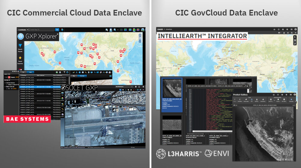
The CIC pairs this data with tools and services to streamline development timelines by ensuring flexible licenses are available for your R&D activities within the CIC ecosystem. As new tools and services become available, we negotiate with the vendors for early and shared access amongst our CIC participants to the latest and greatest capabilities from established vendors in the remote sensing market. This visual shows a few or our early integrators, and as new vendors are integrated, we’ll let the community know!
Your all-access pass
The CIC supports and enables industry, scientific, academic, and governmental R&D activities by facilitating access to commercial remote sensing data. Riverside Research integrates the hardware, software, processes, data, tools, internet accesses, demonstration capabilities, and other IT infrastructure required to execute CIC participant SIBR projects and meet R&D objectives. Our CIC offers:
- Exposure to diverse and emerging data and data types for more data scientists
- Increased interaction between content providers and new application developers; enables cloud-hybrid, multi-INT applications
- Lowered entry barriers by eliminating the need for a user-developed system
- Integrated orchestration-to-analysis workflow
- Timely teaming, technology, and tipping
- Accelerated access and use of commercial remote sensing solutions and innovation
Right where you want it
Are you looking for a cloud-hosting environment where you can easily access commercial data for development and test—all from one place to safely develop, load, and test capabilities?
Our trusted, unclassified, virtual development platform provides access to R&D-licensed commercial remote sensing phenomenologies (e.g., EO, radar, IR, RF), connects emerging and established vendors with shared application tools and services, and facilitates GEOINT, MASINT, and Multi-INT research and development. The CIC includes:
- An ecosystem of commercial data providers (CDPs)
- A network of application developers
- Common R&D data and COTS/GOTS tools (e.g., loading, discovery)
- Common testing data (curated, tagged)
- Robust DevOps environment
- Hybrid cloud-ready infrastructure
- Protected intellectual property and data rights
- Maturing secure data fabric
CIC mission, vision & values
Mission: Provide data scientists and algorithm developers with a virtual development and test platform and access to new and diverse commercial remote sensing data to develop algorithms, tools, and services.
Vision: Work in the Nation’s interest to offer proven expertise and experience in commercial remote sensing to solve problems through innovation, agility, and creative thinking.
Values: Encourage partnerships and connect emerging and established users across USG and industry with shared application tools, services, and diverse commercial constellation data.

Participant Agreements: We offer access to a secure, virtual, cloud-based ecosystem to perform R&D using existing and emerging commercial sources to develop and test algorithms, tools, and services accelerating USG objectives.
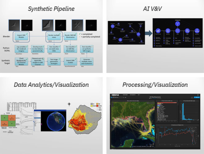
Commercial Experts: We offer our commercial experience, data scientists, and phenomenology experts to support efforts using the CIC to perform commercial utility assessments, new sensor development, synthetic data V&V, data value/usability studies, and more.
Products and Services: We offer access to CIC-based products and services such as synthetic data generation, data tagging, AI/ML V&V, data compression, data geo-registration, and more.
Work With the Commercial Innovation Center
Press Inquiries About the CIC
Commercial Innovation in the News
- Commercial Imagery
- Satellite Launches
- EO-MSI
- SAR
- HSI
- RF
- SSA
Commercial Imagery
With hurricane season brewing, Pentagon stops sharing satellite weather data - USA Today
... images that forecasters can't get anywhere else. ... The Navy confirmed the data cutoff, adding that the satellite program was already "scheduled for ...
Satellite data loss could hinder peak hurricane forecasts | FL Keys News
A satellite image provided by NOAA shows Tropical Storm Florence, upper ... satellite imaging for at least a month. Unless that deadline is ...
Defense Department will cut off key satellite data for hurricane forecasting - Scripps News
NOAA announced Monday morning it will delay cutting off meteorological satellite data until the end of July, a month later than initially planned.
Pentagon will no longer share satellite data that tracks hurricanes overnight
... satellite data, gathered as part of the military's Defense Meteorological Satellite Program. ... imagery arrives (the 'sunrise surprise').
Accuracy of surface water maps derived from radar satellite imagery compared to ...
The results were validated using high resolution satellite imagery, and analysis of variance was calculated. S2MSI consistently produced higher ...
Satellite imagery reveals ongoing work at Iranian nuclear site bombed by US | CNN
New satellite images show continuing work at Iran's Fordow nuclear enrichment plant, which was struck by US B-2 bombers just over a week ago.
Speckle filtering in satellite SAR change detection imagery - TNO RESOLVER
Testing the new method on a repeat-pass satellite SAR image-set gave an accurate overview of changes compared to a colour-composite of both images ...
Look: NASA Satellite Images Reveal Mysterious Blast Site of 1908 Tunguska Event ... - The Debrief
The mysterious blast site of the Tunguska Event of 1908 is revealed in satellite images obtained by NASA's Operational Land Imager.
Federal agents swarming of Cypress Park Home Depot caught on video | KTLA
... satellite image provided by the National Oceanic and Atmospheric ... To what extent would you support or oppose increased regulation of artificial ...
Satellite Industries | Concrete walls are up, and momentum is building in Dahlonega ... - Instagram
... future. more. June 19 · satelliteindustries. •. Follow. Photo by Satellite Industries in Satellite Industries. May be an image of cooler, generator.
Crucial Hurricane Monitoring Data Will Go Offline at the End of July - The New York Times
At the planet warms, satellite imagery allows scientists to track the seasonal decline of sea ice. “Without that record, especially for the ...
The Defense Department will still maintain the satellite program will cease sharing the ... - Facebook
The Defense Department will still maintain the satellite program will cease sharing the imagery with NOAA and NASA.
Fordo Nuclear Site Work Taking Place in Iran, Satellate Images Show - The New York Times
Satellite Imagery Shows Iran at Work at Fordo Nuclear Site. Amid competing assessments of how badly the enrichment facility was damaged in U.S. ...
Maxar Launches Sentry Persistent Monitoring Suite for Predictive Intelligence
... satellite imagery collected over more than two decades. This unrivaled geospatial foundation provides training data for advanced AI/ML computer ...
Satellite data crucial for hurricane forecasts won't be cut off for another month: NOAA
... Satellite dataWeather satellitesData distributionMicrowave imageryStorm intensityHurricane season. chevron right arrow icon. WASHINGTON (TNND) — The ...
Well I guess they missed. Fresh satellite images show ongoing activity at Iran's Fordow nuclear site
Well I guess they missed. Fresh satellite images show ongoing activity at Iran's Fordow nuclear site | Fox News New satellite imagery shows ...
Trump delays plan to cut satellite data access crucial to hurricane forecasting
... image. Toggle caption. Skip to ... In last week's notice, the agency said that “due to recent service changes” the Defense Meteorological Satellite ...
Satellite pics reveal Iran racing to REBUILD destroyed nuke site as UN warns of new bomb plot
Satellite pictures have emerged showing fresh construction work at Iran's top nuclear facility 'Mount Doom' after it was bombed by the US.
BAER team completes Soil Burn Severity map for Trout Fire - USDA Forest Service
... satellite imagery. The SBS map estimates approximately 9,996 acres (20%) of the fire is unburned/very low, approximately 28,860 acres (58%) have ...
BAER team completes Soil Burn Severity map for Trout Fire | NM Fire Info
... verifies unburned/very low, low, moderate, and high SBS categories from satellite imagery. The SBS map estimates approximately 9996 acres (20%)…
Satellite Launches
Tracking Macroplastics Leeching Into Rivers from Space - Universe Today
Scientists have developed a new method to identify and map plastic waste in urban areas using satellite imagery, offering new hope for tracking ...
Future Batch of Data Transport Satellites on Hold for Space Force
Close Image. An artist's rendering of Northrop ... The experimental Tranche 0 satellites have launched and contracts are already awarded to launch ...
Trump delays plan to cut satellite data access crucial to hurricane forecasting
... Images. Trump administration. Trump delays plan to cut satellite ... launches waves of Gaza airstrikes after new displacement orders. 4h ago ...
Satellite imagery reveals ongoing work at Iranian nuclear site bombed by US - AOL.com
Iran says it has fulfilled all its obligations towards the watchdog. PICTURE BLURRED. Before Israel launched its 12-day military campaign aimed at ...
Pentagon will no longer share satellite data that tracks hurricanes overnight
But meteorologists said the loss of the data gathered by three defense satellites, carrying instruments called the Special Sensor Microwave Imager/ ...
SpaceX to Launch New Space Force Weather Satellite - YouTube
SpaceX to Launch New Space Force Weather Satellite. 74 views · 6 hours ago ... BlackSky to Develop a New Line of Wide-field Imaging Satellites.
Vodafone and AST SpaceMobile European Joint Venture 'SatCo' Plans D2D Offering in 2026
Imagery and Sensing Rocket Lab Launches Mission for HawkEye 360 With Experimental Satellite ... satellite service” for Europe. In addition, SatCo ...
Space Force Awards SpaceX $81M Task Order for USSF-178 - Via Satellite
Imagery and Sensing Rocket Lab Launches Mission for HawkEye 360 With Experimental Satellite ... Space Launch (NSSL) Phase 3, Lane 1 task order.
Satellite imagery reveals ongoing work at Iranian nuclear site bombed by US | CNN
... launched from a US submarine hit the Isfahan site in central Iran. Ad Feedback. The US Massive Ordnance Penetrator (MOP) bombs targeted the two ...
With hurricane season brewing, Pentagon stops sharing satellite weather data - USA Today
Their infrared sensors capture images over an area of 1,600 nautical miles, beaming down information twice every day. Launched between 2003 and 2009, ...
Look: NASA Satellite Images Reveal Mysterious Blast Site of 1908 Tunguska Event ... - The Debrief
... Space Mission Planning Advisory Group (SMPAG), both of which were launched to increase international cooperation in the detection and response to ...
A Silent Threat: How NOAA Satellites Help Save Lives in Low Visibility and Fog | NESDIS
SWFO-L1 Launch. About. Our Mission · What We Do · Leadership · Our ... The Visible Infrared Imaging Radiometer Suite (VIIRS) aboard the JPSS satellites ...
New Satellite Network to Scan Earth Every 20 Minutes, Revolutionizing Global Wildfire Monitoring
(Image credit: Muon Space). The FireSat Protoflight: Early Success. The FireSat Protoflight satellite, launched on March 14, 2025, aboard SpaceX's ...
MTG-S1 satellite hosting the Sentinel-4 instrument is ready for liftoff - ESA
... Space Safety Applications Enabling & Support ESA Web TV Videos Images ... satellite to the rocket and provides a secure mount during launch. The ...
Rocket Lab to launch ESA's first LEO-PNT navigation satellites - GPS World
... Photo: SatLab · SatLab unveils USV system for 3D hydrographic surveys. Jun 30, 2025. Photo: TrustPoint · TrustPoint launches third low-Earth orbit ...
India to fast-track 52 military satellites for better surveillance at borders - The Hindu
... Representative image | Photo Credit: Getty Images/iStockphoto ... The Defence Space Agency (DSA) will oversee the operation of the newly launched ...
Trump admin will cut hurricane forecasters out of key satellite data in one month
... satellite imagery. A current NOAA staff member also told CNN the agency ... Bezos' Blue Origin company launches 13th human flight to space.
Satellites trace a triangle above Gemini North Telescope | Space photo of the day for July 1, 2025
In this image, the long exposure shows three satellites streaking across the sky to form a triangle shape. Researchers are working to find ways to ...
Meteorological satellites observe temperatures on Venus | The University of Tokyo
Imaging data from Japan's Himawari-8 and -9 meteorological satellites have ... The Himawari-8 and -9 satellites, launched in 2014 and 2016 ...
Long-dead satellite emits strong radio signal, puzzling astronomers | CNN
However, they absolutely can damage a spacecraft.” NASA ...
EO-MSI
Tracking Macroplastics Leeching Into Rivers from Space - Universe Today
With its resolution capabilities and field of view it can collect up to 680,000 square kilometres of imagery per day. Worldview-3 satellite (Credit: ...
Iran Scrambles At Fordow Nuclear Site After US Strike – What Do The New Satellite Images Reveal?
Iran Scrambles At Fordow Nuclear Site After US Strike – What Do The New Satellite Images Maxar Technologies images shows vehicles at the Fordow Fuel ...
JinkoSolar and ib vogt Partner to Deliver High-Efficiency Tiger Neo Modules for Spain's 513 ...
... Satellite · Lake Michigan ... JinkoSolar and ib vogt Partner to Deliver High-Efficiency Tiger Neo Modules for Spain's 513 MWp Segovia Solar Cluster.
Intel suggests US strikes on Iran caused limited damage – WaPo - Azerbaycan24
Intercepted conversations show that Tehran officials expected a worse impact from the attacks on nuclear facilities Maxar Satellite Imagery...
Satellite imagery reveals ongoing work at Iranian nuclear site bombed by US | CNN
Maxar said it “reveals ongoing activity at and near the ventilation shafts and holes caused by last week's airstrikes on the Fordow fuel enrichment ...
Skynopy Secures 15 Million Euros in Funding for Ground Network Service - Via Satellite
Imagery and Sensing Maxar Releases Geospatial Monitoring Solution For Predictive Intelligence ... satellite data downlink services for Earth ...
Space Force Awards SpaceX $81M Task Order for USSF-178 - Via Satellite
Imagery and Sensing Maxar Releases Geospatial Monitoring Solution For Predictive Intelligence ... satellite, which reached operational acceptance ...
Look: NASA Satellite Images Reveal Mysterious Blast Site of 1908 Tunguska Event ... - The Debrief
... NEO threats that may arise. “International Asteroid Day aims to raise public awareness about the asteroid impact hazard,” a statement on the UN's ...
New 3D glacier visualizations provide insights into a hotter Earth - Ohio State News
Measurements in this study were made using daily high-resolution images gathered by the PlanetScope satellite constellation, which researchers ...
Satellite-based maritime info pact signed between MDA Space, Canadian government
... satellite surveillance data and analytics services for dark vessel detection ... AI-powered object detection technology to be provided to NGA by Maxar.
Fordo Nuclear Site Work Taking Place in Iran, Satellate Images Show - The New York Times
Source: Satellite image captured on June 29 by Maxar Technologies. By Samuel Granados. June 30, 2025, 2:23 p.m. ET. Satellite images taken in the ...
Maxar Launches Sentry Persistent Monitoring Suite for Predictive Intelligence
Image: Maxar. Sentry integrates AI-powered capabilities unique to Maxar—including multi-source constellation orchestration, geospatial fusion, and ...
Military, mullahs, and ISI: The toxic mix behind Pakistan's democratic collapse - Firstpost
Military, mullahs, and ISI: The toxic mix behind Pakistan's democratic collapse. Nalin Kumar Mohapatra • June 30, 2025, 19:00:10 IST. Whatsapp ...
AI-powered object detection technology to be provided to NGA by Maxar
... satellite imagery. To meet delivery timelines, Maxar will integrate imagery collection from its own satellite constellation and that of partner ...
NGA Awards Maxar Delivery Order in $290M Luno A Earth Observation Contract
Maxar Technology is partnered with Satellogic, Enabled Intelligence and ... satellite constellations. Maxar's partners also include Enabled ...
The D Brief: Putin's summer offensive in Sumy; 'Largest combined strike' vs. Ukraine so far
Developing: Iran is already repairing the Fordow Fuel Enrichment plant struck by U.S. forces last week, according to new satellite photos from Maxar ...
Exclusive: Satellite Pics Show India Attack Split Pak Terror Camps Into Half - YouTube
New high-resolution satellite imagery with NDTV shows, for the first time, the impact of Indian precision strikes against two major terrorist ...
The attacks on Iran didn't achieve anything more than harm nonproliferation - Al Jazeera
A closer satellite view shows holes and craters on a ridge at Fordow underground complex, ... Maxar Technologies via Reuters]. After launching direct ...
Maxar launches monitoring system for large-scale vessel tracking - Smart Maritime Network
Part of the wider Sentry system architecture, Maritime Sentry leverages Maxar's 250-petabyte archive of satellite data and integrates data from ...
Skynopy raises €15M for real-time, high-speed satellite ground network - Tech.eu
An operational test using Skynopy's ground station network was successfully conducted by Airbus and Skynopy to download data from the Pléiades Neo ...
SAR
Marine Disasters: Why India Needs a New Oil Spill Response Framework Now
... EOS-04 satellite provided spatial images, using Synthetic Aperture Radar (SAR) sensors capable of monitoring oil spills regardless of lighting or ...
NASA eyes summer streaming liftoff on Netflix - Space Daily
"Our Space Act of 1958 calls on us to share our story of space ... Finland partners with ICEYE to develop national satellite surveillance system.
Smallsat hardware, services provider AAC Clyde sells equity at discount, shares drop
... satellites, plus ground network, from Finland's Iceye · Home · Mobility ... satellite, launch and the international space businesses. He is a ...
Vodafone and AST SpaceMobile European Joint Venture 'SatCo' Plans D2D Offering in 2026
Latest News. Government/Military Finnish MoD Looks to Purchase SAR Satellites from Iceye ... satellite constellation. “This is an important ...
Skynopy Secures 15 Million Euros in Funding for Ground Network Service - Via Satellite
Latest News. Government/Military Finnish MoD Looks to Purchase SAR Satellites from Iceye ... satellite data downlink services for Earth ...
Space Force Awards SpaceX $81M Task Order for USSF-178 - Via Satellite
Latest News. Government/Military Finnish MoD Looks to Purchase SAR Satellites from Iceye ... Space Vehicle 2 and BLAZE-2 for small satellite prototypes.
Soaring temperatures set new record for June in Spain - Space Daily
Finland partners with ICEYE to develop national satellite surveillance system · 24/7 Energy News Coverage · Consortium plans global shift toward net ...
Finland signs LoI to acquire SAR satellites from ICEYE - Air Force Technology
The Finnish MoD) has signed a LoI with ICEYE, a European company specialising in space and defence technology, for SAR satellites.
Formlabs Teams Up with DMG MORI in Japan | The Voice of 3D Printing / Additive Manufacturing
AMR Satellite · AMR Data Center · AMR Satellite · MMX · HP · IMTS2026 · 3ERP · HP ... EOS Zone · The 3D Systems Zone · The HP Zone · Bioprinting Zone ...
A New Exoplanet Resets the Scale - Eos.org
The planet was first detected by the Transiting Exoplanet Survey Satellite (TESS) in early 2020 and confirmed with additional observations over the ...
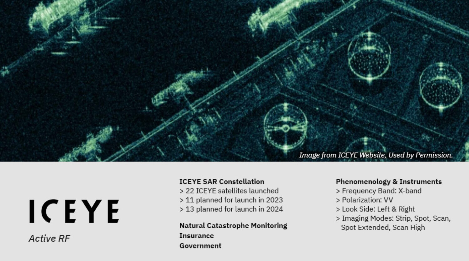
Finland Ministry of Defense selects ICEYE for Space-Based Intelligence
ICEYE and the Finnish Ministry of Defense have signed a Letter of Intent enabling the Finnish Defense Forces to acquire ICEYE SAR satellites.
Pentagon Reconsiders Satellite Strategy with SpaceX's Starshield in the Mix - Orbital Today
... orbit constellation,” Saltzman said. “So we are simply looking at ... ICEYE SAR Satellites To Be Used By Finnish Defence Forces. Satellites 30 ...
EU Reveals Bold Crackdown Bid on Space Junk as Orbit Turns Chaotic
Mega constellations, which involve over 100 satellites, and giga constellations ... ICEYE SAR Satellite. Satellites 2 hours ago. ICEYE SAR Satellites To ...
ICEYE SAR Satellites To Be Used By Finnish Defence Forces - Orbital Today
A new agreement will give the Finnish Defence Forces access to ICEYE SAR satellites for use in space-based surveillance.
Finland partners with ICEYE to develop national satellite surveillance system
ICEYE currently operates the world's largest SAR satellite constellation, offering persistent global monitoring with unmatched revisit rates. Its ...
Airbus CO3D optical constellation satellites on their way to launch - GIM International
June 30, 2025. German radar satellite TerraSAR-X marks 100,000th orbit. June 30, 2025 ...
German radar satellite TerraSAR-X marks 100000th orbit - GIM International
On 26 June 2025, the German radar satellite TerraSAR-X completed its 100000th orbit around Earth, marking a major milestone that highlights almost ...
DOD stops providing NOAA with satellite data - YouTube
2:19 · Go to channel. ISRO Launch Today | ISRO's 101st Satellite Mission Takes Flight, Loses EOS-09 Minutes Later. NDTV•65K views · 53:33 · Go to ...
Capella Space hiring Director of Business Development, Global Missions (APAC) in Asia ...
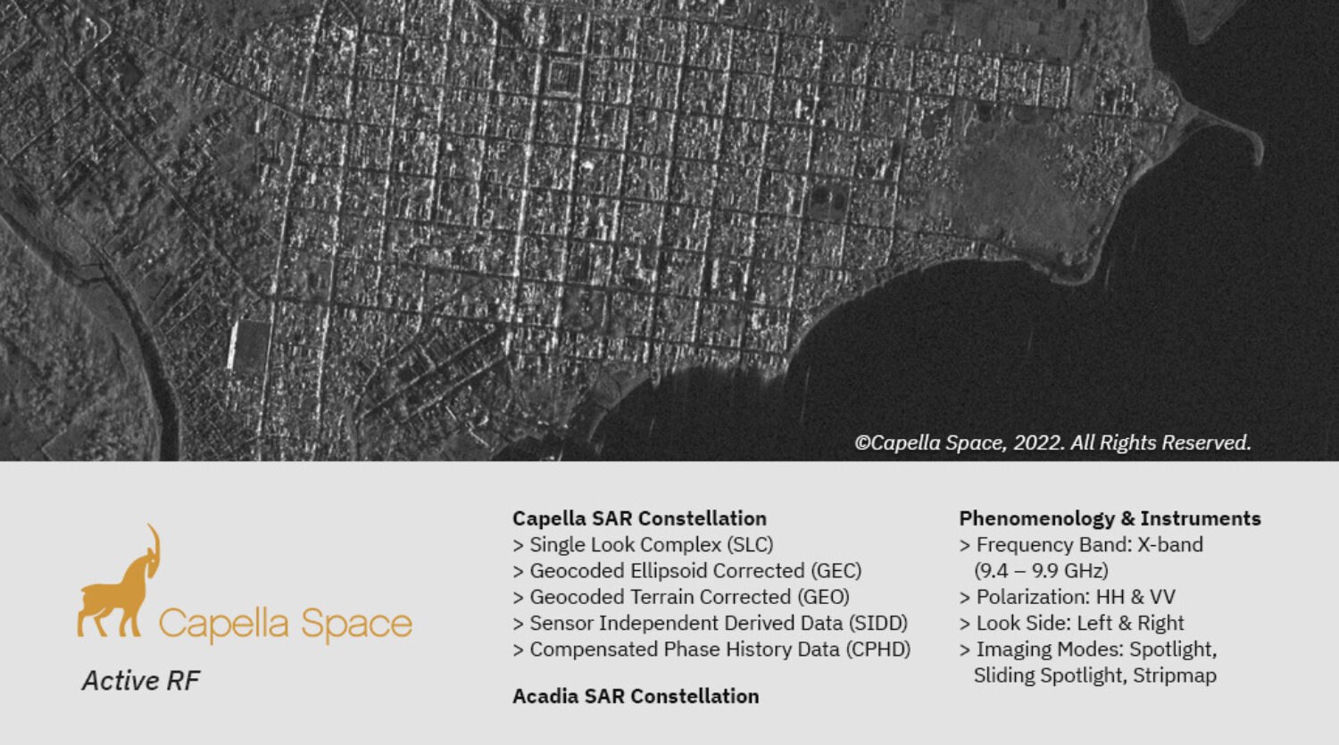
A pioneer in the Earth observation industry, Capella is the first U.S. company with a constellation of Synthetic Aperture Radar (SAR) satellites, ...
Homegrown satellite imagery tool wins top Google prize - Newspaper - DAWN.COM
... Images Special Reports Aurora Dawn News · Eos/Icon/Young World Cityfm89 Herald Teeli. Copyright © 2025, Dawn. NewsKit Publishing Platform by ...
HSI
Starlink Elevates In-Flight Wi-Fi Performance | Ookla®
Ekahau Sidekick 2 · Ekahau Connect · GIS Datasets · Map Elements® · RootMetrics ... Starlink's low-earth orbit (LEO) satellite constellation drives ...
Top 10 countries with the most satellites in space | Trending News - The Indian Express
Russia's in-orbit constellation consists of 244 satellites ... Telesat, MDA, GHGSat and Northstar are the major satellite companies operating from ...
RF
New Satellite Imagery Shows Iran Is Up to Something at Fordow - The Western Journal
The satellite images have reignited concerns ... The spire of a residential house stands over Harvard University in Cambridge, Massachusetts, on.
Smallsat hardware, services provider AAC Clyde sells equity at discount, shares drop
become a subscriber! AAC Clyde SpaceInflecionNowo Global FundorbcommSaabUK Space AgencyVireon ... satellite, launch and the international space ...
Space Forge Launches In-Space Manufacturing Satellite, ForgeStar-1 - SpaceWatch.GLOBAL
Unseenlabs Announce BRO-18 Mission to Track Invisible Maritime Activity. by Joshua Faleti. June 18, 2025. Momentus to Host Portal Space Systems ...
Satellite Broadband Surges: Costs Plummet as Global Capacity Skyrockets
OneWeb; Orbcomm; Sateliot; Skylo; SpaceX; SEAKR Engineering; SES; Telesat; T-Mobile; Viasat/Inmarsat. For more information about this ...
Monolithic Power Systems, Inc. (NASDAQ:MPWR) Shares Sold by Spire Wealth Management
Spire Wealth Management lowered its position in shares of Monolithic Power Systems, Inc. ... satellite communications applications. See Also. Five ...
Decoding ORBCOMM satellite telemetry data using ORBCOMM receiver 2025 06 29 (Long Version)
ORBCOMM's OG-2 satellites are part of a second-generation constellation designed to provide global Machine-to-Machine (M2M) and Internet of Things ...