We Are Better Together
Our Commercial Innovation Center (CIC) is a first-of-its-kind, online development and test platform that provides a secure, virtual, open ecosystem and test sandbox for developers and researchers. We do it by harnessing the combined powers of commercial remote sensing, unclassified open datasets, cloud technologies, in a secure development ecosystem fueled by new, emerging, and seasoned tools, services and data to create solutions that keep our nation safe. The Riverside Research CIC is the place where commercial subject matter experts come together securely to collaborate and create the best commercial solutions to real world scenarios before they're integrated and deployed in the field.
Together, we win
It’s not as much fun to play in the sandbox by yourself, right? We know from experience that it’s the collective work of many people with diverse experiences and backgrounds that create the most effective solutions. By design, the CIC encourages partnerships, increases data accessibility, integrates app development, and facilitates the creation of transition-ready prototypes. Because of our unique position as a nonprofit in the defense space, we can provide the neutral environment where collaborative innovation thrives. As demonstrated on this video, capitalizing on all commercial sensors available improves our progress towards persistent observation.
Access to rich datasets
Data is the one thing that is guaranteed to continuously grow and change. Technology entrepreneurs’ success revolves around access to these data and developing improved AI and machine learning tools creating integrated and advanced applications for businesses in support of (United States Government) USG needs.
Advanced tools and applications
Technology innovation in artificial intelligence, machine learning, and augmented and virtual reality present significant entrepreneurial opportunities, yet all require geospatial data for development. Early-stage entrepreneurs, academic researchers, and innovators will now have access to the large datasets that are traditionally only available to large, established industry players. Such datasets are often too costly for early-stage entrepreneurs and researchers to acquire, and even if the datasets are made available, they are often not packaged in a manner that allows innovators to work with the data—they are overwhelmingly unwieldy and non-standardized. The CIC data environment seeks to solve that problem, allowing researchers and entrepreneurs new opportunities for experimentation, testing, and training.
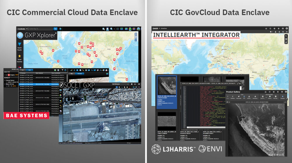
The CIC pairs this data with tools and services to streamline development timelines by ensuring flexible licenses are available for your R&D activities within the CIC ecosystem. As new tools and services become available, we negotiate with the vendors for early and shared access amongst our CIC participants to the latest and greatest capabilities from established vendors in the remote sensing market. This visual shows a few or our early integrators, and as new vendors are integrated, we’ll let the community know!
Your all-access pass
The CIC supports and enables industry, scientific, academic, and governmental R&D activities by facilitating access to commercial remote sensing data. Riverside Research integrates the hardware, software, processes, data, tools, internet accesses, demonstration capabilities, and other IT infrastructure required to execute CIC participant SIBR projects and meet R&D objectives. Our CIC offers:
- Exposure to diverse and emerging data and data types for more data scientists
- Increased interaction between content providers and new application developers; enables cloud-hybrid, multi-INT applications
- Lowered entry barriers by eliminating the need for a user-developed system
- Integrated orchestration-to-analysis workflow
- Timely teaming, technology, and tipping
- Accelerated access and use of commercial remote sensing solutions and innovation
Right where you want it
Are you looking for a cloud-hosting environment where you can easily access commercial data for development and test—all from one place to safely develop, load, and test capabilities?
Our trusted, unclassified, virtual development platform provides access to R&D-licensed commercial remote sensing phenomenologies (e.g., EO, radar, IR, RF), connects emerging and established vendors with shared application tools and services, and facilitates GEOINT, MASINT, and Multi-INT research and development. The CIC includes:
- An ecosystem of commercial data providers (CDPs)
- A network of application developers
- Common R&D data and COTS/GOTS tools (e.g., loading, discovery)
- Common testing data (curated, tagged)
- Robust DevOps environment
- Hybrid cloud-ready infrastructure
- Protected intellectual property and data rights
- Maturing secure data fabric
CIC mission, vision & values
Mission: Provide data scientists and algorithm developers with a virtual development and test platform and access to new and diverse commercial remote sensing data to develop algorithms, tools, and services.
Vision: Work in the Nation’s interest to offer proven expertise and experience in commercial remote sensing to solve problems through innovation, agility, and creative thinking.
Values: Encourage partnerships and connect emerging and established users across USG and industry with shared application tools, services, and diverse commercial constellation data.

Participant Agreements: We offer access to a secure, virtual, cloud-based ecosystem to perform R&D using existing and emerging commercial sources to develop and test algorithms, tools, and services accelerating USG objectives.
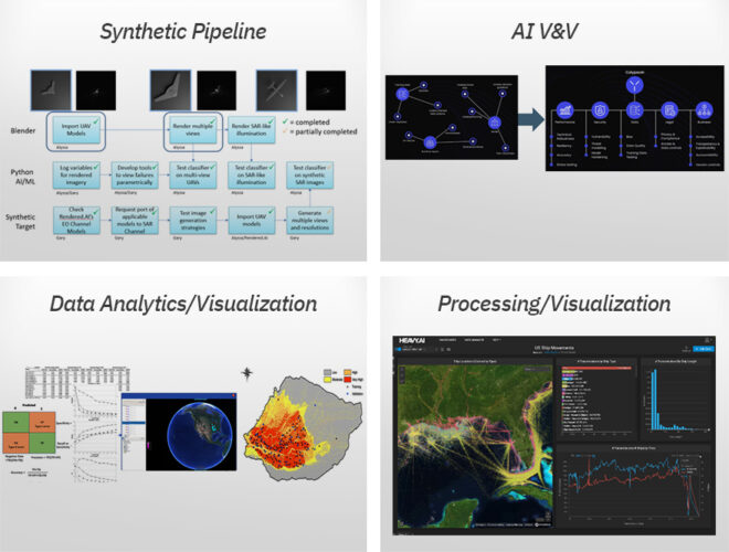
Commercial Experts: We offer our commercial experience, data scientists, and phenomenology experts to support efforts using the CIC to perform commercial utility assessments, new sensor development, synthetic data V&V, data value/usability studies, and more.
Products and Services: We offer access to CIC-based products and services such as synthetic data generation, data tagging, AI/ML V&V, data compression, data geo-registration, and more.
Work With the Commercial Innovation Center
Press Inquiries About the CIC
Commercial Innovation in the News
- Commercial Imagery
- Satellite Launches
- EO-MSI
- SAR
- HSI
- RF
- SSA
Commercial Imagery
Iran won't retaliate against the US, but will continue uranium enrichment, official says
Satellite image of the Fordow Fuel Enrichment Plant (FFEP) after US strikes. 4. Satellite images show damages to the nuclear site, which US officials ...
Planet Labs Stock (PL): Satellite Contract Win | Value The Markets
Planet Labs operates in the aerospace and defense sectors, specializing in satellite imagery and data. It has proven its capabilities in ...
Boeing secures $2.8 billion US satellite contract - Reuters
The Evolved Strategic Satellite Communications (ESS) program will deliver space-based nuclear, command, control, and communications for the U.S. ...
Quantum Communications by Satellite: SpeQtral And Thales Alenia Space Launch New ...
... Thales quantum satellite. Insider Brief. SpeQtral and ... Satellite Imagery. May 24, 2021. Keep track of everything going on in the ...
Elon Musk's xAI gets permit for methane gas generators | Tennessee - The Guardian
A satellite image that the Southern Environmental Law Center, a legal non-profit, took on Tuesday and shared with the Guardian shows at least 24 ...
Unlocking Space for Business with satellite solutions - Innovation News Network
For example, in the financial services sector, insurance companies are using satellite imagery to verify insurance claims, saving time and money that ...
Brandclub - Garmin dezl OTR720, Large 7' GPS Navigator, Custom Truck Routing, Satellite ...
... Satellite Imagery shows high-resolution overhead views of your destination. As part of the dēzl community of fellow truck drivers, you can easily ...
Bezos-backed methane tracking satellite lost in space | CBC News
The satellite was part of groundbreaking efforts to track methane pollution and make information public. Capping methane leaks is one of the ...
Exploring the influence of urban green space and urban morphology on urban heat Islands ...
The initial technique uses high-resolution satellite imagery for remote sensing to evaluate the cooling effects of vegetation canopies. This is ...
Space Force picks Boeing for $2.8B strategic communications program - Defense News
... Satellite Communications program. Boeing edged out Northrop Grumman for ... Intelligence and Weapons systems business. “We designed an ...
US IMINT Firm OnGeo's High-Resolution Satellite Imagery Debunks Claims of Damage to ...
SOURCE: AFI. On May 10, 2025, high-resolution satellite imagery released by OnGeo, a US-based imagery intelligence (IMINT) firm, ...
Officials Work to Meet Pentagon's Need for Space Capabilities - DVIDS
The evolution of military space assets such as satellite imagery ... For instance, soldiers in Afghanistan planning to raid an al-Qaida cell would ...
Defense Secretary Gates and Australian Foreign Minister Smith Sign Military Satellite Agreement
Defense Secretary Gates and Australian Foreign Minister Smith Sign Military Satellite Agreement [Image 2 of 2] · CANBERRA, AUSTRIA · 02.22.2008 · Photo ...
Need satellite imagery suitable for dynamic zooming and 3D visualization : r/gis - Reddit
Need satellite imagery suitable for dynamic zooming and 3D visualization. Programming. Hello everyone,I'm building a 3D Earth renderer using ...
Quantum, AI And Space Anchor Pentagon's Deep Tech Convergence Strategy
... satellite and space-based applications. The Pentagon is not just preparing for future wars — it's building the scaffolding for long-term ...
Iran Update, July 3, 2025 | Institute for the Study of War
Commercially available satellite imagery captured on June 21 shows that Israeli airstrikes destroyed a central missile launch structure, one ...
NOAA - Facebook
NOAA's Center for Satellite Applications and Research (STAR) at NESDIS plays an important role in hurricane preparedness. STAR's satellite data...
Atlantic Hurricane Season 2025 Looping Satellite and Radar Maps - WXII
View the latest satellite, radar, and wind gust speed data from the tropical Atlantic to North Carolina beaches.
Dynamic and morphological analysis of oceanic vortex streets in the Yellow Sea using ...
The seasonal characteristics of tidal currents have a significant impact on the vortex street characteristics. High-resolution satellite imagery ...
Satellite Image Captures Massive Wildfire Smoke Over Greece - tovima.com
A satellite image released by Meteosat-12 shows the extent of the wildfire smoke plumes drifting across large parts of Greece.
Satellite Launches
Russia hits Ukraine with biggest overnight attack of war - as Trump says he's disappointed in Putin
Russia launched its biggest aerial attack of the war so far on Saturday ... For context: A former Soviet satellite state, the Kyrgyz Republic ...
Satellite evidence points to heightened operations at N. Korean nuclear site - DailyNK
Analysis of the photos shows that as North Korea boosts its nuclear weapon production, production at the Pyongsan refinery has increased.
Satellite Transmission Launches Acquisition Excellence Week - DVIDS
Defense Secretary Donald Rumsfeld will kick-off Acquisition and Logistics Excellence Week, Sept. 10 with a live satellite broadcast.
Sabin Center, activists launch state-focused 'Model Climate Laws Initiative' - POLITICO Pro
CLIMATEWIRE | The Sabin Center for Climate Change Law announced an effort Wednesday to write model policies for states trying to curb emissions.
Iran Update, July 3, 2025 | Institute for the Study of War
Commercially available satellite imagery captured on June 21 shows that Israeli airstrikes destroyed a central missile launch structure, one ...
China successfully launches new test satellite - People's Daily Online
The satellite was launched at 5:35 p.m. (Beijing Time) and entered the preset orbit successfully. (Photo by Ma Wenbo/Xinhua). XICHANG, July 3 ...
Dynamic and morphological analysis of oceanic vortex streets in the Yellow Sea using ...
... imagery, synthetic aperture radar imagery, and satellite altimetry data. ... launched into orbit on November 5, 2021 (Guo et al., 2023). It is ...
Navy to stop sharing satellite weather data with NOAA - Military Times
The DMSP satellites capture global imagery from space twice a day ... The WSF-M, first launched in 2024, can analyze sea ice, soil moisture ...
£75.6m tender opens for UK's first mission to remove space debris
Orpheus satellite mission to shield UK comms from space weather set for 2027 launch · First images captured by Vera Rubin Observatory in Chile leave ...
Progress MS-31 launches as ISS hosts private crew, prepares for another handover
Launch Roundup: ULA scrubs launch of Kuiper satellites,... June 10 ... (Lead image: Progress MS-31 launches to ISS on July 3, 2025. Credit ...
Geospatial Imagery Analytics Market worth $18.55 billion by 2030 - Yahoo Finance
Additionally, the decreasing cost of satellite launches and the rise of commercial satellite operators have made satellite imagery more affordable ...
Russia launches Progress 92 cargo mission to space station - YouTube
SpaceX launches European weather satellite, nails landing ... Downloading Images From US Military Satellites. saveitforparts•1.5M ...
Russia Is Struggling To Build Warplanes - Newsweek
Satellite images shared with Newsweek by Earth imaging company Planet ... launch cruise missiles. The Tupolev Tu-160M. A Tupolev Tu-160M ...
Raven Air Defense System Downs Four Drones in First Combat Engagement - Militarnyi
US Postpones Launch of Epoch 1 Missile Warning Satellites ... Satellite Images Confirm Destruction of Helicopters and Air Defenses at Kirovske Air Base.
Ukraine hit Russia's Nebo-M radar sea-launched bomber UAVs - Euromaidan Press
The assault, captured on video and confirmed through satellite imagery, further highlights Ukraine's evolving drone capabilities and further depletes ...
SpaceX Still Pushing for Access to EchoStar's 2 GHz Spectrum - Broadband Breakfast
... Photo of Jameson Dempsey, director of satellite policy at SpaceX ... satellite for testing a U.S.-based service, and plans to launch another.
US Postpones Launch of Epoch 1 Missile Warning Satellites - Militarnyi
Epoch 1 satellites are part of a promising US military satellite constellation. They will track launches of intercontinental ballistic and hypersonic ...
How to see China's Tiangong space station and the ISS in the predawn sky this week
Here's how it works. images of two H-shaped space stations on a starry ... launch | Space photo of the day for July 3, 2025. 4. Watch Russia's ...
Experimental satellite launched from Xichang center - Chinadaily.com.cn
China launched an experimental satellite into space on Thursday ... The content (including but not limited to text, photo, multimedia ...
Ukraine's Uncrewed Surface Vessels Are Now Launching Bomber Drones To Attack Crimea
Ukraine launched bomber drones from sea ... New satellite imagery and an official video has revealed more about the scale of destruction and ...
EO-MSI
'Google Maps': Public access satellites expose location of billions of dollars of Australian ...
“You can also access a bit more detailed data through commercial purchase of satellite imagery from Maxar or similar companies if so inclined. In ...
Planet Labs Stock (PL): Satellite Contract Win | Value The Markets
Competitive Landscape. Planet Labs competes with companies such as Maxar Technologies, BlackSky, and Spire Global, which also focus on satellite ...
'The Bomb Lady' and the Forerunner of the 'Bunker Buster' Used in Iran | Complementary
... MAXAR WATERMARK MUST NOT BE CROPPED OUT –. Satellite image ©2025 Maxar Technologies. They parted before Duong could get the man's name. “I didn't ...
Defense: German government signs satellite services deal with Planet Labs - Agenzia Nova
“The agreement also includes access to PlanetScope and SkySat data, as well as AI-based solutions to improve situational awareness and maritime domain ...
Iran slams IAEA's 'double standards' - China Daily
This handout satellite image provided by Maxar Technologies and dated July 1 shows activity near the perimeter building and southern holes caused ...
Keurig Dr Pepper (KDP) Receives a Hold from Evercore ISI - The Globe and Mail
In a report released yesterday, Robert Ottenstein from Evercore ISI maintained a Hold rating on Keurig Dr Pepper, with a price target of $37.00.
Starlink-guided narco sea drone caught doing test run for cartels with two dishes
The two-way satellite communication that Starlink dishes provide could ... The best mainstream gamer in 2025 - Lenovo Legion 5 15 Laptop Review.
US-Iran nuclear talks to resume in Oslo next week for first time since war -- report
Israel says Iran recently took steps toward weaponization. This handout satellite picture provided by Maxar Technologies, and taken on June 22 ...
US strikes set back Iran's nuclear program by up to two years - Pentagon reports | SOFREP
... Satellite image of Iran's Fordo fuel enrichment site, July 1, 2025 ...
Satellite Data Services Market Set to Surpass Valuation of US$ 67.02 Billion By 2033
Maxar Technologies; Orbital Insight; Planet Labs; SURREY SATELLITE TECHNOLOGY LTD; Thales; York Space Systems; Other Prominent Players. Key Market ...
North Korea, Russia: More North Korean Troops To Join Russians in Ukraine War - Stratfor
Worldview- News at demand · Americas · Asia-Pacific · Eurasia · Europe · Middle ... Background: Satellite imagery seen by CNN seems to suggest Russian ...
Bunker busters delay Tehran's atomic program by up to two years, officials say | Fox News
The Fordo nuclear site in Iran. This satellite image provided by Maxar Technologies shows damage at the Fordow enrichment facility in Iran after ...
Satellite evidence points to heightened operations at N. Korean nuclear site - DailyNK
(WorldView-3). I examined the recent release of wastewater into the settling pond using high-resolution satellite imagery taken in late May.
O3b mPOWER satellites to expand SES medium-Earth orbit constellation
The O3b mPOWER constellation is designed to operate at roughly 8,000 ... AI-powered object detection technology to be provided to NGA by Maxar.
Iran ends cooperation with UN nuclear watchdog after Israel, US strikes
This handout satellite image provided by Maxar Technologies and taken on February 12, 2025 shows an overview of the Isfahan enrichment facility.
The U.S. Defense Department said that Iran's nuclear development schedule has been ...
A view of Iran's Fordow nuclear facility captured in satellite imagery on the 1st (local time). [Courtesy of Maxar Technology/AFP = Yonhap News].
Iran won't retaliate against the US, but will continue uranium enrichment, official says
... Satellite image ©2025 Maxar Technologies/AFP via Getty Images. “Our policy has not changed on enrichment,” Takht-Ravanchi said. “Iran has every ...
Tracking macroplastics leaching into rivers from space - MSN
Worldview-3 satellite. Credit: Maxar Technologies. Scientists have developed a new method to ...
US slaps sanctions on Iran's oil smuggling network, Hezbollah finance firm
... satellite image provided by Maxar Technologies and dated July 1, 2025, shows an overview of the Fordo Fuel Enrichment Plant complex in central ...
Starlink registration in Pakistan expires; setback to satellite internet | Samaa TV - YouTube
Comments · Hamid Mir's Shocking Revelations | Live With Nasrullah Malik | Neo News | JH2W · Vasay Chaudhry VS Qaiser Piya | Who is More Handsome?
SAR
Satellite spies both ISS and China's Tiangong space station photo of the day for July 4, 2025
... SPACE... Canon EOS R6 Mark II and RF 35mm f/1.4L on a wooden floor. 1. Best Canon cameras 2025: Upgrade your photography with these models on Amazon ...
Boeing Awarded $2.8B USS ESS Contract | Joint Forces News
... satellites and has already proven on-orbit aboard the commercial O3b mPOWER constellation. ... ICEYE Satellite Data for NATO ACO and ISR for RNLAF. You ...
Another eye in sky from ISRO to observe Earth - MSN
... Space Research Organisation's (ISRO's) 101st mission, having launched a more sophisticated eye in the sky — the earth observing satellite EOS-09 ...
Planet expands defense partnerships with key AI surveillance contracts - Space War News
Finland partners with ICEYE to develop national satellite surveillance system ... ICEYE Synthetic Aperture Radar (SAR) satellites. This ...
July 2025 skywatching: Bright planets and a summer constellation - Earth.com
Look for it near the Pleiades star cluster and two brilliant stars – Aldebaran and Capella. Mars is visible in the western sky shortly after ...
Satellite Data Services Market Set to Surpass Valuation of - GlobeNewswire
Fleet operators such as Iceye now bundle emissions disclosures alongside imagery licenses so that corporate ESG auditors can record indirect Scope 3 ...
Satellite Mega Constellation Market Is Going to Boom | Major - openPR.com
... ICEYE, Rocket Lab, Surrey Satellite Technology, Arianespace. Request PDF Sample Copy of Report: (Including Full TOC, List of Tables & Figures ...
Third-ever confirmed interstellar object blazing through Solar System - Space Daily
Six satellites launched for ICEYE as constellation expansion gains momentum · WHO says all Covid-19 origin theories still open, after inconclusive ...
Mapfre Re to licence ICEYE's flood insights data - Life Insurance International
ICEYE operates a synthetic aperture radar satellite constellation that offers flood extent and building-level inundation data worldwide, often ...
Seraphim's June newsletter notes NATO win for ICEYE - QuotedData
D-Orbit continued its leadership in space logistics with the launch of its 18th and 19th Orbital Transfer Vehicles, optimising satellite deployment.
Kadaster chairman Frank Tierolff passes away at 57 | GIM International
German radar satellite TerraSAR-X makes 100,000th orbit. June 30, 2025 ...
Seraphim Space Investment Trust Highlights Key Portfolio Milestones and Industry Advancements
... satellite navigation system, and ICEYE's strategic partnerships and investment in SAR satellite intelligence. These advancements underscore SSIT's ...
SpaceTech Sector Newsletter – June 2025 | Company Announcement - Investegate
ICEYE deployed six SAR satellites, including its first for the Royal ... satellite broadband constellation, which will compete directly with SpaceX's ...
Possible interstellar object zooming through Solar System: ESA - Space Daily
Bezos-backed methane-tracking satellite lost in space · Blackout at ... Six satellites launched for ICEYE as constellation expansion gains momentum ...
Lawsuit says Trump's immigration crackdown has put LA 'under siege' in defiance of federal law
... Satellite · Lake Michigan Beach and Boating · Lake Michigan Summer ... Paz, who was detained by ICE agents outside a Hollywood Home Depot on ...
SpeQtral-Thales Alenia Space Agreement for the Development of Satellite Quantum ...
Space: Senate's final yes, here are the details of the bill · Satellites. Rheimetall and Iceye plan satellite production collaboration · vega avio ...
Seraphim Space I.T. - SpaceTech Sector Newsletter – June 2025 - Research Tree
ICEYE deployed six SAR satellites, including its first for the Royal ... successfully expanded its satellite constellation with the launch of three ...
Senior Technical Lead / Senior Software Engineer - ICEYE - Space Crew
Who are we? ICEYE is the global leader in synthetic aperture radar (SAR) satellite operations for Earth Observation, persistent monitoring, and ...
Coherent, not chaotic—surprising order found in Brahmaputra-Jamuna River channel migration
... satellite imagery. Scientists—and many of the 600,000 people living in ... This story is republished courtesy of Eos, hosted by the American Geophysical ...
RF
Satellite Data Services Market Set to Surpass Valuation of US$ 67.02 Billion By 2033
... orbital pass, shortening agricultural advisory cycles for the satellite data services market. ... Spire Global in March 2024 for employing autonomous ...
Satellite Data Services Market Set to Surpass Valuation of - GlobeNewswire
Airbus SE; ORBCOMM; Boeing; GomSpace; Lockheed Martin Corporation; Maxar Technologies; Orbital Insight; Planet Labs; SURREY SATELLITE TECHNOLOGY LTD ...
Marine Big Data Market Size Worth USD 10.5 Billion by 2032 - Industry Today
... satellite images, sensor-based readings, Automatic Identification ... Spire Global, BMT Group Ltd., ORBCOMM Inc., and MarineTraffic. These ...
Unseenlabs selected by ESA to join the Copernicus Contributing Missions Program
As part of the proposal, Unseenlabs has also included future services from its upcoming Next-Gen constellation, further extending the range of RF ...
SpaceTech Sector Newsletter – June 2025 | Company Announcement - Investegate
Spire Global launched six low earth multi-use receiver (LEMUR) ... HawkEye 360 successfully expanded its satellite constellation with the ...
UNOOSA and Exolaunch Award Satellite Launch Opportunities to Bolivia, Guatemala ...
... Satellite Launch Opportunities to Bolivia, Guatemala, Jordan and ... Unseenlabs Announce BRO-18 Mission to Track Invisible Maritime Activity.
Seraphim Space I.T. - SpaceTech Sector Newsletter – June 2025 - Research Tree
HawkEye 360 successfully expanded its satellite constellation with the launch of three Cluster 12 satellites aboard · Rocket Lab's Electron rocket.